

China May Anger Neighbors With Map Including Disputed Areas

China’s government is issuing a new official map, which will include the nation’s “full” territory, including several areas disputed with other nations.
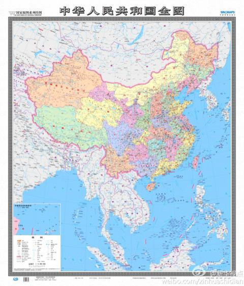
The new map, which will be released later this month by China’s National Administration of Surveying, Mapping and Geoinformation, will now include 130 disputed areas that China is claiming belongs to it, including the much debated Diaoyu/ Senkaku islands.
Previous editions of officially issued maps were presented horizontally, and only included islands in a separate box and typically not to scale. This new map will include all disputed areas to scale, outlining what China believes to be the entirety of the nation’s land and maritime territories.
Xu Gencai, the editor-in-chief of Sinomaps Press, the company distributing the new maps, told Xinhua News Agency that the goal in distributing these new editions is to officially stake China's territorial claims with the rest of the world, as well as its own citizens.
“The new map will be very significant in enhancing Chinese people’s awareness of national territory, safeguarding China’s marine rights and interests, and manifesting China’s political-diplomatic stance,” Xu said.
The new map will undoubtedly ignite a firestorm of criticism from several governments, including Taiwan and Japan, both of which lay claim to the Diaoyu/ Senkaku islands. The Spratlys, Paracels, Pratas, the Macclesfield Bank and the Scarborough Shoal were also included. They are disputed between China and Taiwan, the Philippines, Vietnam, Brunei and Malaysia.
This is not the first time China’s mapping has stirred up controversy among its Southeast Asian neighbors.
China printed new passports last year that included watermarks depicting China as well as 90 percent of the South China Sea and several other disputed islands, much to the dismay of several governments. Officials from Taiwan, Vietnam, India and the Philippines all publicly denounced the passport maps. The mapped areas that marked the new passports, however, did not include the Diayou/ Senkaku islands.
Lu Chang-shui, head of the Mainland Affairs Council’s Department of Information and Liaison, says the government-issued map coming out later this month has an entirely different use and meaning from the ones included in the passports.
“A passport represents national sovereignty and a map is for a country’s internal use,” Lu said in the Taipei Times.
“Consequently, the council will use different approaches to deal with the map and the passport.”
Regardless of how the government draws up its maps, including areas that are disputed by several different nations is bound to instigate anger. And as China continues to beef up its military with new maritime and air weapons and technologies, that anger may be accompanied by anxiety about rising Chinese might.
© Copyright IBTimes 2025. All rights reserved.
- MOST POPULAR IN World


