Flight MH370 Update: Search To Focus On ‘New Priority Area’ In Southern Indian Ocean
Authorities from Australia, Malaysia and China announced Thursday that the next phase of the search for the missing Malaysian Airlines Flight MH370 will move farther south of the initial underwater search zone to an area that is described as “the highest priority for future search efforts.”
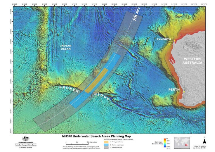
The next round of search operations for the missing jetliner will focus on a 23,166-square-mile portion of the seabed in the southern Indian Ocean along an arc defined on the basis of fresh analysis of all existing information by expert satellite working groups, Australia's Joint Agency Coordination Centre, or JACC, said in a statement. According to reports, Australian officials also reportedly said they were confident that the Boeing 777 was on autopilot before it crashed into the Indian Ocean.
“Specialists have analysed satellite communications information—information which was never initially intended to have the capability to track an aircraft—and performed extremely complex calculations,” Warren Truss, Australia's deputy prime minister and minister for infrastructure and regional development, said. “The new priority area is still focused on the seventh arc, where the aircraft last communicated with satellite. We are now shifting our attention to an area further south along the arc based on these calculations.”
Australian Transport Safety Bureau, or ATSB, Chief Commissioner Martin Dolan told reporters in Canberra: "Certainly for its path across the Indian Ocean, we are confident that the aircraft was operating on autopilot until it ran out of fuel," Associated Press reported, adding that when asked if the autopilot could be activated automatically under a default setting, Dolan replied: "The basic assumption would be that if the autopilot is operational it's because it's been switched on."
Truss also said that a report would be released by the ATSB on Thursday revealing the basis for defining the new search area. The next phase of the search for the plane's wreckage, which is expected to begin in August and take up to 12 months, will include a bathymetric survey, or mapping of the ocean floor, and will be followed by a complete search of the sea floor, Truss said.
“The bathymetric survey has already commenced, with the Chinese survey ship Zhu Kezhen and the Australian-contracted vessel Fugro Equator conducting operations in the areas provided by the Australian Transport Safety Bureau,” he said, adding that it would take about three months to map the ocean floor.
Referring to ATSB's claim that the plane was on autopilot during its flight over the Indian Ocean, Truss said, "We couldn't accurately, nor have we attempted to, fix the moment when it was put on autopilot," AP reported. "It will be a matter for the Malaysian-based investigation to look at precisely when it may have been put on autopilot."
The equipment used in the search going forward will include a “towed side scan sonar, a multi-beam echo sounder and a sub bottom profiler,” JACC said, in the statement.
Efforts to locate Flight MH370, which have dragged on for more than 100 days and led to one of the most expensive search operations in aviation history, has yielded little in the way of substantial clues that might help understand what happened to the jet, which went missing on March 8 with 239 people on board, shortly after leaving Kuala Lumpur for Beijing.
© Copyright IBTimes 2026. All rights reserved.
- MOST POPULAR IN Business