

Satellite Images Show Dramatic Change In Greenland Glaciers In Just 21 Years

KEY POINTS
- The important rocky outcrops have become "free-standing islands"
- Without contact with the rocks, ice can flow more freely into the ocean
- Such glacier melting due to temperature rise can contribute to sea-level rise
Satellite images of a part of Greenland show the dramatic change in the area's glaciers in just two decades, highlighting the impact of rising temperatures.
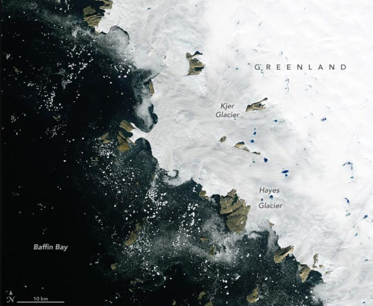
For its Nov. 8 image of the day, NASA Earth Observatory shared two satellite images of northwest Greenland along Melville Bay. Both natural-color images show a 50-mile (80-kilometer) stretch of the coastline area, spanning the Kjer Glacier and the Hayes Glacier, as captured by satellites. However, one is from Sept. 3, 2000, while the other is from 21 years later, on Sept. 21, 2021.
In the image from 2000, which was captured by the Enhanced Thematic Mapper Plus (ETM+) instrument on the Landsat 7 satellite, some of the rocky outcrops that help stop the "oceanward flow" of the ice are still visible.
In the 2021 image, captured by the Operational land Imager (OLI) instrument of the Landsat 8 satellite, these outcrops have become "free-standing islands." Meanwhile, the ice can be seen scattered and flowing into the ocean.
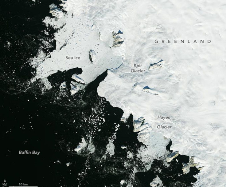
As the agency explained, both Kjer and Hayes are outlet glaciers or a type of valley glacier where an inland ice sheet or ice cap can flow through. The floating ice shelf on Kjer Glacier disintegrated in 2012. By 2021, the rocks that once slowed the flow into the ocean have become merely surrounded by "open water and a mixture of sea ice and icebergs, or mélange," the satellite image shows.
"Having lost contact with the rocks, the glacier's inland ice can flow even more rapidly toward the ocean," the agency explained.
"Kjer is experiencing a nearly four-fold increase in ice flow due to the collapse of its floating ice shelf, likely due to melting by warmer ocean waters," Alex Gardner, snow and ice scientist at NASA's Jet Propulsion Laboratory, said as per NASA Earth Observatory. "This has led to increased contributions of ice to the ocean and is accelerating sea level rise."
According to the agency, the Greenland Ice Sheet used to gain as much of the ice that it lost around the 1970s. But by the mid-1990s, the ice loss became more rapid and the Ice Sheet could no longer retain this balance.
This is because as the temperatures continue to rise, glaciers are melting faster than they can accumulate new snow, NASA noted. When they do, the water runs into the ocean and contributes to sea-level rise.
"Between 2002 and 2021, Greenland shed about 280 gigatons of ice per year, adding 0.8 millimeters (0.03 inches) per year to global sea level rise," NASA Earth Observatory noted.
© Copyright IBTimes 2025. All rights reserved.
- MOST POPULAR IN Science


