

Typhoon Vongfong, Philippines’ First Tropical Storm Of 2020, Makes Landfall

KEY POINTS
- Satellite images show Typhoon Vongfong's landfall in Eastern Samar in the Philippines
- It is the country's first tropical storm in 2020
- Tens of thousands of people had to be evacuated because of the storm
- Experts forecast Typhoon Vongfong to weaken as it moves across the islands
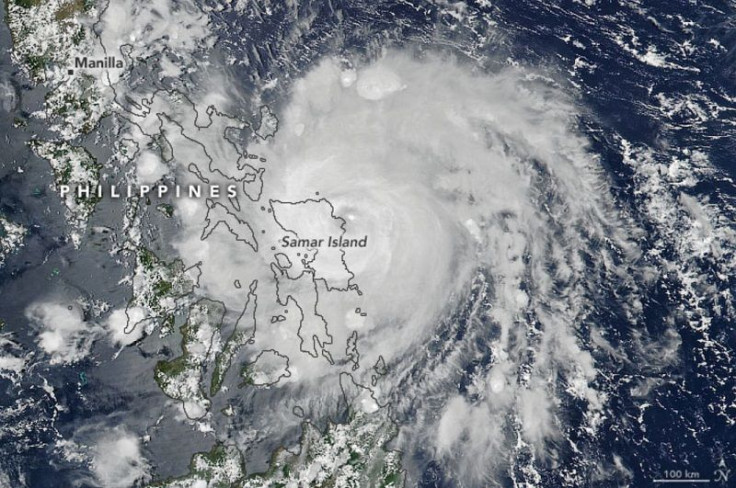
The first tropical storm of 2020 in the Western Pacific Ocean has made landfall in the Philippines. NASA and National Oceanic and Atmospheric Administration (NOAA) satellite images show the tropical storm over Philippine islands.
At around noon local time Thursday, Typhoon Vongfong made landfall in the province of Eastern Samar and moved into an area devastated by Typhoon Haiyan in 2013, according to NASA Earth Observatory. Typhoon Vongfong is the first tropical storm in the Philippines for 2020.
In an image captured by the Visible Infrared Imaging Radiometer Suite on NASA and NOAA’s Suomi NPP satellite, the storm can be seen over Samar Island, which is the third largest island in the Philippines.
Tens of thousands of people live along the coast where the typhoon landed, prompting authorities to evacuate them. Because of the coronavirus pandemic, however, the evacuation centers will only accept half of their usual capacity, and all the evacuees will be required to wear face masks.
The storm, locally known as "Ambo" is predicted to move north-northwest across most of the Philippine islands, including Luzon, the largest and most populated island in the country. Weather models predict that certain places would experience as much as 25 to 50 centimeters of rainfall.
On May 13, the NOAA-20 satellite saw Typhoon Vongfong at 12:03 p.m. EDT, with the image showing an intensifying storm.
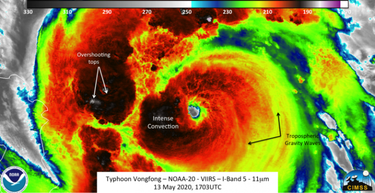
"The imagery showed features that one would expect from an intensifying storm, including overshooting tops and tropospheric gravity waves In addition, a clear eye could be seen as well," William Straka III of the University of Wisconsin-Madison said in a NASA blog. Straka was the one who created the imagery using the satellite data.
Despite the initial intensity of the storm, the Joint Typhoon Warning Center forecasts Typhoon VongFong will weaken as it continues to move towards Visayas and Luzon regions.
At the time of writing this article, the Philippine Atmospheric, Geophysical and Astronomical Services Administration has noted five landfalls and another one in the coming hours. According to AccuWeather Senior Meteorologist Dave Houk, the mountains in each of the islands the storm passes through may help weaken it.
Past landfalls: (1) San Policarpo, Eastern Samar; (2) Dalupiri, Northern Samar; (3) Capul, Northern Samar; (4) Ticao Island, Masbate; & (5) Burias Island, Masbate.#AmboPH may make another landfall in Bondoc Peninsula, southern Quezon this morning. pic.twitter.com/PdxJCpVK1u
— PAGASA-DOST (@dost_pagasa) May 14, 2020
The Philippines is prone to tropical cyclones because of its geographical location, with the country experiencing an average of 20 tropical cyclones each year.
© Copyright IBTimes 2025. All rights reserved.
- MOST POPULAR IN World


