

What Are Whiting Events? Researchers Shed Light On Mysterious Water Phenomenon [Photo]

KEY POINTS
- Whiting events have been observed for decades
- Researchers analyzed satellite data, creating detailed records of the events
- They found a seasonal pattern and a strange increase in the affected areas
Scientists have known of a mysterious water phenomenon called a "whiting event" for a while now but have yet to figure out the mechanisms behind it. Using satellite data, researchers are shedding light on it.
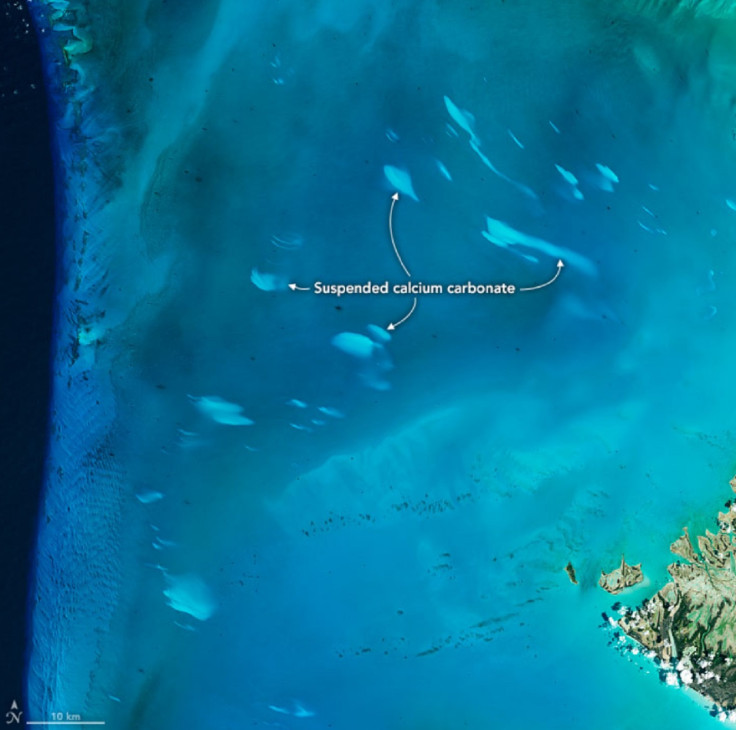
A whiting event is a phenomenon wherein a body of water is sporadically splattered with strange, milky-white patches. Such events have been observed in places like Fayetteville Green Lake, New York and Ten Thousand Islands, Florida. In the Bahama Banks, scientists have been noticing the phenomenon since the 1930s, according to NASA Earth Observatory.
Previous sampling has found that the white patches are composed of calcium-carbonate particles suspended in the water, the agency noted. Scientists have thought of various mechanisms that may be responsible for the events such as the currents or perhaps phytoplankton blooms. However, what exactly causes them remains a mystery.
"(L)ittle is known about their distributions and particularly about their long-term changes," researchers wrote in their study, which was published in Remote Sensing of Environment.
For their work, the researchers sought to shed further light on the phenomenon by analyzing satellite images of the Bahama Banks, spanning 18 years, from 2003 to 2020.
"In doing so, the research team assembled the longest and most detailed monthly, seasonal and annual records of Bahama Bank whiting events ever created," NASA Earth Observatory noted, citing one of the authors, Chuanmin Hu of the University of South Florida.
One of the images, seen below and shared by the NASA Earth Observatory, shows a whiting event off the coast of the Great Bahama Bank on April 4, 2015. It was captured by the Operational Land Imager (OLI) instrument on the Landsat 8 satellite.
The researchers found a "strong seasonality" in the appearance of the phenomenon in both the Great Bahama Bank and Little Bahama Bank, in that it more frequently appears during spring (primary peak) and wintertime (secondary peak). The individual patches have also varied in size from 0.1 to 226 square kilometers in the Great Bahama Bank and 0.1 to 95 square kilometers in the Little Bahama Bank.
Interestingly, they also found that the total area affected by the events actually got bigger through the years, from affecting an average area of 25 square kilometers in 2003 to affecting 300-350 square kilometers in 2014-2015, NASA Earth Observatory said.
However, the events started decreasing again after 2015. And by 2020, the total affected area returned to the pre-2011 levels of 25 square kilometers.
Analyzing some environmental factors, the researchers propose a "Goldilocks" scenario wherein certain factors, together, made for the right conditions for whiting events from 2011 to 2015. However, further measurements are needed to truly understand the mechanisms behind the phenomenon.
"I wish I could tell you why we saw that peak in activity, but we're not there yet," Hu said, as per NASA Earth Observatory. "Ultimately, we need to do more field experiments and pair that with remote sensing research like this to better understand the formation processes."

© Copyright IBTimes 2025. All rights reserved.
- MOST POPULAR IN Science


