

Winter Storm Euclid Delivers Belated Christmas Snow To US East Coast
It might have come too late to give a White Christmas to the Northeastern U.S., but Winter Storm Euclid is arriving just in time to foul up travel plans across the Eastern Seaboard after dumping plenty of snow west of the Mississippi.
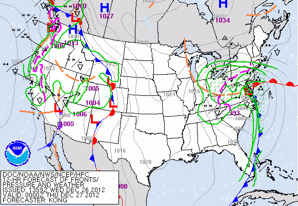
Meteorologists predict that Euclid will hit the Chesapeake Bay area with heavy rains today, with snow and a wintry mix in the Northeast. The National Weather Service has issued winter weather and winter storm advisories for much of the Northeast, with blizzard warnings in place for parts of Indiana and Ohio. A snowstorm becomes a blizzard when it has sustained winds of at least 35 miles per hour and enough snow to reduce visibility to less than a quarter of a mile ahead, according to the NWS.
“Overnight and Thursday, heavy snow will quickly engulf Upstate New York and northern New England, possibly mixing with sleet and even some freezing rain at times. Some areas will pick up over a foot of snow,” Weather Channel forecaster Guy Walton wrote on Wednesday morning.
Euclid also brings some heavy wind gusts, of up to 50 miles per hour in some places. The snowstorm should exit the U.S. on Friday, heading out to sea over the coast of Maine.
As of Wednesday morning, the Illinois city of Albion had the highest snowfall from Euclid, with more than 18 inches.
While the Northeast braces for a blizzard, the Southeast is battening down the hatches after a bumper crop of tornadoes hit on Christmas Day. Preliminary reports suggest there were at least 19 tornadoes, with the strongest one appearing to be a cyclone that moved through Mobile, Ala. If the initial count is verified, that would set a record for tornadoes on Christmas, according to Weather Underground meteorologist Shaun Tanner.
Happily, there do not seem to be any deaths caused by the tornadoes.
“This is outstanding news and a tribute to the preparations residents took before the storm, as well the precautions taken when the NWS issued Tornado Warnings,” Tanner wrote.
Euclid is part of the first generation of winter storms that are getting names, thanks to a policy change at the Weather Channel.
“Our goal is to better communicate the threat and the timing of the significant impacts that accompany these events,” Weather Channel expert Tom Niziol wrote in October. “The fact is, a storm with a name is easier to follow, which will mean fewer surprises and more preparation.”
The 2012-2013 winter has already brought five storms that the Weather Channel deemed worthy of naming. The first of these, Athena, hit soon after Hurricane Sandy.
NWS is not following the naming convention for winter storms, and Joel Meyers, president of Weather Chanel rival Accuweather, claims naming winter storms is misleading and poor science.
“Hurricanes are well-defined storms following a path that can be tracked. Winter storms are often erratic, affecting different areas unevenly,” Myers said in a statement in October.
© Copyright IBTimes 2025. All rights reserved.
- MOST POPULAR IN Science


