

Hurricane Irene Virginia: Governor Declares State of Emergency
Hurricane Irene continued its path of destruction on Thursday towards the East Coast, and it could have big effects in Maryland and Virginia.
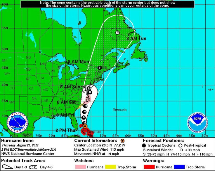
As the Category 3 storm battered the northern Bahamas on Thursday, Eastern cities and states began to prepare for the incoming storm.
On Thursday, Virginia Governor Bob McDonnell declared a state of emergency ahead of the westward moving, behemoth of a storm.
At this time, I encourage all Virginians to gather items they may need this weekend in case of power outages and disruptions in public services and to make sure their family members and friends are also prepared for this storm, McDonell said.
The Category 3 storm is expected to hit the Carolinas over the next 36 hours, according to the National Hurricane Center, and could strengthen to a Category 4 storm around that time, as it begins its likely ascent up the East Coast.
One current scenario for Hurricane Irene's path would bring it right past Richmond, Va., Washington, D.C., and Baltimore, Md. This scenario would bring heavy rainfall and heavy winds, potentially upwards of 100 mph; right past the nation's capital only days after an earthquake rocked the area.
If it does follow that path it could create an estimated $100 billion in insured losses, according to a five-year-old study by Munich Re. That figure doesn't take into account loss of productivity or loss of life from the catastrophic event.
The impending Irene disaster has mobilized towns and businesses across the Mid-Atlantic region to start preparing for an evacuation. Ocean City, Md has asked vacationers to stay away from the popular destination, citing a possibility of 9.5 inches of rain and dangerous winds over the weekend.
Amtrak officials have canceled all service below the DC area and could cancel more services, if the storm continues to develop as expected. It currently services from its Baltimore station and up, but that could all change if the storm rocks the Northeast, as expected.
In addition to McDonnell's state of emergency mandate, the Navy has moved 27 ships out to sea from their normal location in the Hampton Roads region of Virginia.
The Navy last moved part of its fleet in that area for Hurricane Isabel in 2003, and only does so when a storm produces a five to seven-foot storm surge. According to a Navy spokesman, the storm is actually so big that it will likely force the Navy to move its ships several hundred miles away.
The Navy moves it ships when storms can produce winds of 50 knots and a five to seven-foot storm surge. The last time it did so was during Hurricane Isabel in 2003. The low-lying Norfolk area, where most of the ships are based, is particularly vulnerable to storm surge. The city regularly floods during strong rains and state emergency management maps shows even a Category 1 Hurricane can flood areas near the base, which is just a few miles north of the downtown waterfront.
The forecasted destructive winds and tidal surge is too great to keep the ships in port, Vice Adm. Daniel Holloway, commander of the Norfolk-based Second Fleet, said in a statement. Having the ships underway also makes them ready and available to respond to any national tasking, including any needed disaster response efforts in the local area after the storm has passed.
For residents in Maryland and Virginia, the storm's potential impact focuses greatly on slight shifts, as the storm isn't expected to hit land in that region. If the storm slightly shifts eastward it would mean less severe weather conditions of mostly just rain, while if it shifts westward it could bring major bad news for the area.
The westward spin could bring heavy rain, significant flooding, power outages, and heavy winds.
© Copyright IBTimes 2025. All rights reserved.
- MOST POPULAR IN Society


