

Britain Braces for Severe Gales, Yellow Alert from Hurricane Katia's Path
The remnants of Hurricane Katia will impact Britain as a strong low pressure system beginning Sunday night, sweeping severe gales across parts of the UK, forecasters say.
The Met Office has issued a yellow alert, telling residents to be aware of the approaching high impact system. Katia's path missed the U.S., and while the storm is weakening in colder Atlantic waters, the Met said much of the UK will likely see gusty wind conditons and intermittent rains throughout the weekend, withe strongest conditions reaching northern and western regions.
Although it will be very windy everywhere, it is uncertain as to exactly which parts of the country will see the very strongest winds -- so we advise everyone to stay up to date with the very latest forecast warnings, said Chief Met forecaster Eddie Carroll.
Hurricane Katia will move fast across the North Atlantic Ocean Saturday, and clip the British Archipelago as the storm becomes a strong extra-tropical for beginning Sunday night and into Tuesday.
Gales and rains will spread over Ireland and Scotland late Sunday through early Monday, continuing through Tuesday, forecasters say.
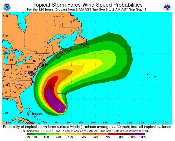
The U.S. and the east North American Coast however, will be spared from Katia's path, except for some coastal areas from northeastern Florida to Newfoundland that are likely to experience rough seas and surf as the storm passes by in the next few days.
Strong upper level steering winds from the west are catching Katia on Friday, pushing the storm on a swift path toward Europe. Thus, Katia will near the U.S., but models are consistent in showing that the storm will turn to the north, remaining east of North Carolina's Outer Banks. Cape Cod, Nova Scotia and Newfoundland -- points of land that stick out into the Atlantic -- could experience the most impact of rough seas and surf.
But in Europe, even the mainland will be impacted by Katia eventually, as northermost France, the Netherlands, and Denmark will experience wind and some rain as a result of the storm. Norway is also likely to get significant impact from the storm.
It's rare that tropical cyclones reach Europe, but Norwegian forecasters warn that Katia could reach Norway on Tuesday or Wednesday of next week, with heavy rains and winds from the storm, extra-tropical at that point.
© Copyright IBTimes 2024. All rights reserved.
-

Bitcoin And Crypto Price Review - Another Myth Gets Busted?
-

Mass Cancellations Loom Despite French Air Union Cancelling Strike
-

Mired In Crisis, Boeing Reports Another Loss
-

Recycled 'Zombie' Misinformation Targets US Voters
-

Hackers Leak Part Of Source Code Of El Salvador's Bitcoin Wallet
-

Azerbaijan Says 'Closer Than Ever' To Armenia Peace Deal Amid Border Talks
-

How UK's Biggest Water Supplier Sank Into Crisis
-

Taiwan Hit By Dozens Of Strong Aftershocks From Deadly Quake
-

Gaza Health System 'Completely Obliterated': UN Expert
-

In Ecuadoran Amazon, Butterflies Provide A Gauge Of Climate Change


