

Civil War Shipwreck Unearthed In Surprising New 3-D Sonar Footage [VIDEO]

The iron-hulled USS Hatteras was the only U.S. Navy ship to sink in the Gulf of Mexico as a consequence of Civil War hostilities, but, 150 years after it slipped beneath the waves, it can finally be seen again -- and in high-resolution 3-D sonar images to boot.
In a battle with the CSS Alabama, a Confederate raider, the 210-foot Hatteras was the clear loser, sinking about 20 miles off the coast of Galveston, Texas, on Jan. 11, 1863.
The National Oceanic and Atmospheric Administration marked the sesquicentennial of the event by releasing a 3-D sonar map -- and associated images -- of the Hatteras shipwreck site, the results of a high-tech mission co-sponsored by NOAA, according to OurAmazingPlanet.com.
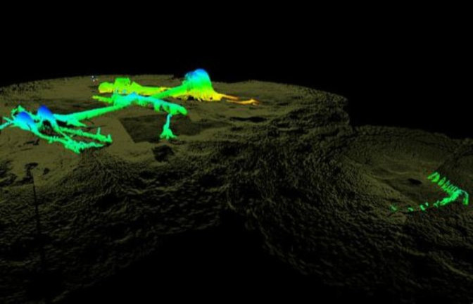
So what makes this 3-D sonar map so interesting? For starters, it can obviously be explored in three dimensions. It might just be the most high-tech shipwreck map ever created.
"Most shipwreck survey maps are two-dimensional and based on observations made by sight, photographs, or by feeling around in murky water while stretching a measuring tape," James Delgado, director of maritime heritage for NOAA's Office of National Marine Sanctuaries, said in a statement. "Thanks to the high-resolution sonar, we have a three-dimensional map that not only provides measurements and observations, but the ability for researchers and the public to virtually swim through the wreck's exposed remains and even look below the surface at structure buried in loose silt."
The 3-D sonar map was created over the course of a two-day expedition carried out by a team of archaeologists and technicians. The Hatteras shipwreck lies beneath 57 feet of water, embedded in sediment. After a series of recent storms unearthed parts of the ship, NOAA jumped at the chance to survey the site.
One of the biggest findings of the expedition was most of a paddlewheel primarily used to propel the ship. New information also shed light on what exactly sank the ship, showing that the Hatteras sustained damage to its engine room and steering column.
More than anything else, historians have been excited to learn more about the Civil War through the project.
"This vessel is a practically intact time capsule sealed by mud and sand, and what is there will be the things that help bring the crew and ship to life in a way," Delgado told the Associated Press.
"You can fly through the wreck," he added. "You're getting a view no diver can get."
Watch a stunning 3-D video of the shipwreck site below.
© Copyright IBTimes 2026. All rights reserved.
- MOST POPULAR IN Science


