Firefighting FUEGO: Proposed Fire Detection Satellite Would Spot Blazes From Space

The fight against raging wildfires may soon be relocated to the sky.
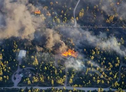
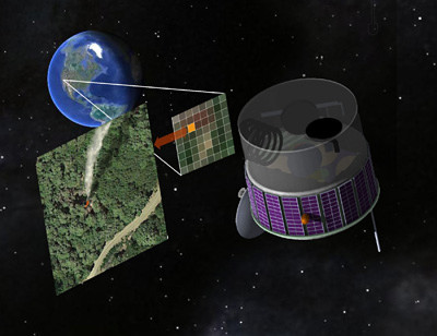
Researchers at the University of California, Berkeley, have presented a fire monitoring system that uses sensitive satellites to monitor fire-prone regions across the U.S. Named the Fire Urgency Estimator in Geosynchronous Orbit (FUEGO), the satellite would take pictures of forests in the Western U.S. several times a minute, continually searching for "hot spots" that could turn into larger blazes, according to the plan published in the October issue of the journal Remote Sensing. FUEGO would be able to identify fires as small as 12 square meters. Upon identifying a blaze, the system would then send out an alert to inform authorities.
According to Scott Stephens, UC Berkeley associate professor of environmental science, increasing the means for early detection would help officials make faster, informed decisions on how to manage the blazes as well as plan for effective evacuations. "Wildfires would be smaller in scale if you could detect them before they got too big, like less than an acre," Stephens said.
To build and launch the satellite, it is estimated, would cost several hundred million dollars, reports PBS. But with cost of fighting fires during the most recent-record breaking wildfire seasons -- fighting fires in 2012 cost $2 billion -- supporters consider the satellites a worthy investment for the nation.
Forest fires are currently spotted mainly by people – either by officials in fire spotter towers or people in affected communities who alert authorities. This method has changed little in centuries.
© Copyright IBTimes 2026. All rights reserved.
- MOST POPULAR IN Technology