

Fort McMurray Wildfires May Double In Size, Albertan And Canadian Officials Warn

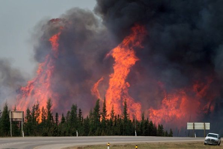
Low humidity, high temperatures and strong winds led Alberta’s Premier Rachel Notley and Canada’s Public Safety Minister Ralph Goodale to warn Saturday that the Fort McMurray wildfires may soon double in size. Already a conflagration of epic proportions, the wildfires might even spread to the neighboring province of Saskatchewan, officials said.
Notley: Fire burning out of control. Burning to the NE. 156,000 hectares, could double. Might reach Saskatchewan border today. #ymm #ymmfire
— Cullen Bird (@CullenBird) May 7, 2016
“The situation remains unpredictable and dangerous,” CNN quoted Goodale as telling reporters.
An estimated 88,000 people have been displaced under evacuation orders issued for the communities of Anzac, Gregoire Lake Estates and Fort McMurray First Nation, as well as the city of Fort McMurray, the unofficial capital of the Canadian oil sands region. About 1,600 buildings have been destroyed.
Alberta wildlife officials expect to fight massive Fort McMurray inferno, in forested area, for months to come. #yeg #ymmfire
— CTV Edmonton (@ctvedmonton) May 7, 2016
Believed to contain about 70 percent of the natural bitumen reserves in the world, Alberta accounts for around 80 percent of the country’s daily crude production, which has been cut by roughly one-third because of the wildfires.
Due to the fact the flames are being force-fed by multiple factors, the reported area of 386,000 acres that has been scorched by the wildfires is really something of a moving target. To put this figure in its proper perspective, it is more than twice the size of New York City.
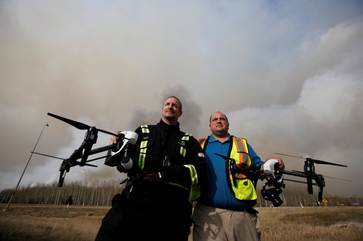
Meanwhile, Alberta will employ drones to investigate the cause of the largest Fort McMurray wildfire, according to Reuters. A company that has previously provided drones to construction and mining firms, Elevated Robotic Services has contracts with the Alberta government and the insurance broker Hub International, said Mat Matthews, the operations and safety manager at the Edmonton-based outfit.
With infrared, ultraviolet and traditional optical cameras, the drones will focus on the hottest spot in the fire and trace it to its source based on time, wind and other variables, Reuters reported. Beginning Tuesday, the cameras will shoot about 800 photographs to produce a map, the news agency said.
“It’s like Google Maps but 100 times better,” Matthews told Reuters while at a police roadblock south of Fort McMurray.
The Alberta government confirmed it had a contract with Elevated Robotic Services, but Hub was not immediately available for comment, Reuters reported.
According to Matthews, the drones “will allow them to determine a cause much faster” than traditional methods used in detecting the sources of wildfires.
© Copyright IBTimes 2024. All rights reserved.
-

IMF Says Global Debt Levels Face 'Great Election Year' Risk
-

Divisions Among Colombia's FARC Dissidents Complicate Peace Talks
-

French Far Right Gets Youthful Vibe With 28-year-old Leader
-

US Fed's Powell Says Inflation Fight May Take 'Longer Than Expected'
-

Mideast-related Oil Price Spike Threatens 'Relatively Good' Economic Outlook: IMF Chief Economist
-

Wine Growers 'On Tip Of Africa' Race To Adapt To Climate Change
-

Despite Olympic Truce, Games Wrestle With Political Fallout
-

What Will The Fed Do With The Latest Inflation Numbers?
-

US Retail Sales Up More Than Expected In March
-

Alexandre De Moraes: Brazil Judge In Feud With Elon Musk


