

Hurricane Irene Path: Category 3 Storm Heads for Carolinas, Northeast
Hurricane Irene has been upgraded to a Category 3 storm, and could even grow stronger, as it approaches the Carolinas and Northeast this week.
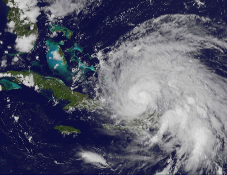
The storm gained Category 3 distinction when its winds hit speeds upwards of 111 mph and it could continue to strengthen as it gets closer to the East Coast, according to The National Hurricane Center. It is the first major Atlantic storm of the year.
The Carolinas have already begun to prepare for it, as Irene continued to pound the Caribbean area on Tuesday. The hurricane rocked the southeastern Bahamas and Turks and Caicos beginning on Tuesday and continuing into Wednesday morning.
The storm is expected to hit central Bahamas by Wednesday afternoon and northeast Bahamas by Thursday before hitting the United States on Friday. It is expected to graze by Florida before potentially hitting the Carolinas as a Category 4 storm, according to recent forecasts.
A Category 4 hurricane carries a very high risk of injury or death to people, livestock and pets due to flying and falling debris, according to the National Weather Service.
This kind of danger has led Ocracoke Island, a tiny barrier island in North Carolina, to already ask its residents to begin to evacuate as it prepares for rain and winds upwards of 135 mph, the biggest hurricane to hit American soil in seven years.
The last big hurricane, of at least Category 3 strength, was Hurricane Jeanne in 2004. The last hurricane of any strength to hit the U.S. was Hurricane Ike in 2008.
Not only could Irene have major impacts in the Carolinas, but the East Coast could feel Irene's impact all the way up to Long Island in New York. The heavy rainfall, high speed winds, and other effects led the Federal Emergency Management Agency to issue a warning to all residents of the East Coast.
Go ahead and make sure you're ready and then if evacuations are required, heed those evacuation orders, said Craig Fugate, manager of FEMA, told ABC News. The Hurricane Center says this storm is going to grow and strengthen...and it's really something people need to be prepared now for so they can be ready if they have to act.
Northeast residents can expect remnants of the hurricane to hit New Jersey by Sunday afternoon before continuing to make its way up to New York and New England, according to forecasters.
There's a lot of uncertainty with the track right now, said Al Cope, a meteorologist with the National Weather Service's Mount Holly office, to the Star Ledger. The center could be off the coast of New Jersey by Sunday afternoon.
From New Jersey, it could make landfall in New York by Sunday evening.
New York, as well as the New England area, could experience heavy rainfall on Saturday ahead of Sunday's arrival of the storm. According to the Weather Channel, only 10 hurricanes have come within 75 miles of Boston since 1851, with Hurricane Bob approaching the area in 1991.
© Copyright IBTimes 2024. All rights reserved.
- MOST POPULAR IN Society


