

Hurricane Katia Path: U.S. Strike Possibility Remains; Tropical Storm Lee Forces New Orleans State of Emergency
The U.S. is on high tropical cyclone alert, as Tropical Storm Lee strengthens and is forecast to inundate the Gulf Coast including New Orleans with possible severe flash flooding, and Hurricane Katia forces U.S. East Coast residents to keep a keen eye on that storm's strengthening and path.
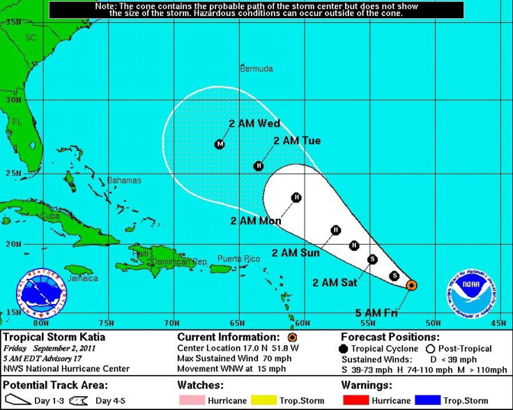
Computer models tracking Katia, currently about 700 miles east of the northern Leeward Islands with winds of 75 miles per hour, continue to show disagreement, according to forecasters. Most scenarios keep the storm away from Florida, but others show northern Florida and perhaps Georgia and the Carolinas could eventually get hit by Katia.
Models also show Katia may reach Category 3 strength by next week, so the U.S. East Coast is closely watching the storm's progress.
Katia became the 11th named storm of the Atlantic hurricane season which runs from June 1 to Nov. 30. Irene became the first to reach hurricane strength, before ravaging a path up the East Coast last week, and power remains out in some areas and the cleanup may take weeks, if not months for some.
But the immediate threat to the U.S. is Tropical Storm Lee, upgraded from Tropical Depression 13 on Friday afternoon. New Orleans has declared a state of emergency, as have the state of Louisiana and Mississippi as forecasts suggest severe flash flooding, torrential rainfall and high winds are likely for days in the Gulf Coast region.
At 2 p.m. EDT on Friday, Tropical Storm Lee had winds of 40 miles per hour, moving northwest at just two miles per hour. Minimum pressure was recorded in the latest reading at 1003 mb.
Tropical Storm Lee, or perhaps eventual Hurricane Lee, poses a significant threat to the U.S. Gulf Coast region through the extended Labor Day weekend.
Heavy rains and flooding are forecast as the storm moves ashore sometime before Monday, forecasters say. The storm packs significant risk because it is slow-moving and the potential exists for major flooding in New Orleans, the city decimated during Hurricane Katrina in 2005.
This could be a very heavy, prolific rainmaker, National Weather Service meteorologist Frank Revitte told MSNBC.
Concerns in New Orleans are rising.
Some models indicate the city could get 15 to 20 inches of rain or more; that's in excess of total rainfall from Hurricane Katrina, which breached levees after 15 inches of rain. That was combined with significant storm surge with raised water levels in Lake Pontchartrain, but 20 inches could push water to dangerous levels again if Lee emerges as near a Category 1 hurricane.
What's more, the Times Picayune reported Friday that a forthcoming Army Corps of Engineers report will give the city's levee system a near-failing grade despite a $10-billion post-Katrina rebuilding job.
The wind threat from the storm is low compared to major hurricanes -- but it also could increase as the storm intensifies, forecasters say. Officials are urging residents with plans along the Gulf Coast this weekend to closely monitor the storm's track and development. Already, some oil companies have ordered evacuations of personnel off offshore rigs as the storm intensifies.
Current models show Tropical Depression 13 would make landfall in southern Louisiana Monday morning as a tropical storm, packing winds of 60 miles per hour. But the forecast also shows the storm would be near the Louisiana coast on Saturday evening, meaning days of torrential rains -- possibly exceeding 20 inches -- will pound the region.
Tropical Storm Lee is the 12th named storm of the Atlantic hurricane season. Last week, Irene became the first hurricane to strike the U.S. since Hurricane Ike in 2008.
Tropical storm warnings have been posted from Mississippi to Texas, including New Orleans, where current forecast models show the biggest threat and potential impact. The National Hurricane Center said the system will pour massive amounts of rain over southern areas of the coast.
Already Friday, New Orleans is being lashed with rains. The forecast calls for a 70 percent chance of precipitation Friday and Saturday, with easterly winds gusting from 20 to 35 miles per hour.
Lee has a slow northwest movement forecast through Friday, followed by an expected turn toward the north on Friday night and Saturday. The center of the cyclone is expected to approach south Louisiana during the weekend. Gradual strengthening is forecast, and the depression could become a tropical storm on Friday.
Forecasters say isolated amounts of rainfall of 20 inches are possible, with widespread accumulations of 10 to 15 inches. Also, storm surge water levels could rise by as much as 2 to 4 feet above ground level of onshore flow.
© Copyright IBTimes 2025. All rights reserved.
- MOST READ


