

Hurricane Sandy Anniversary 2014: Flood Insurance To Rise For Many NYC Homeowners
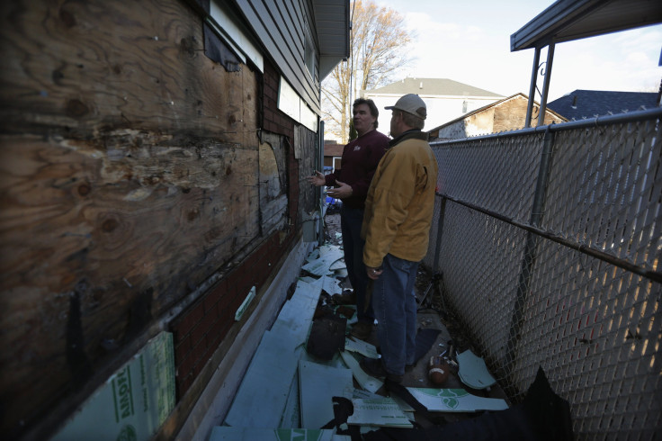
The floodwaters came from the ocean, and they came from the bay, driven by Hurricane Sandy into the first floor of Lucia Acevedo’s house, two blocks from the beach at Brooklyn’s Coney Island. The storm caused about $90,000 worth of damage to her home.
Back in 1990, Acevedo and her then-husband bought the house because it was near family, and in an affordable neighborhood. But these days, Acevedo, who is now divorced, doesn’t know if she'll be able to afford to stay—and pay for flood insurance.
“That is the mystery,” says the city government employee and mother of two.
Acevedo is one of roughly 5.3 million policyholders in the National Flood Insurance Program (NFIP), the principal source of flood coverage for U.S. homeowners. In the time she’s been rebuilding since Sandy struck in 2012, so have policymakers grappled with an oceanic challenge: how to shore up the NFIP — which owes the Treasury Department $24 billion — without sticking homeowners with price increases.
“The program cannot continue to be bailed out by an act of Congress every time there is a big flood,” historian Scott Gabriel Knowles, author of "The Disaster Experts: Mastering Risk in Modern America," says. “It will become politically untenable.”
Congress has passed not one but two laws in as many years to address the country’s flood insurance problem. The first one, the Biggert-Waters Flood Insurance Reform Act, phased out certain subsidies granted to older homes, under a swift timeframe. The political backlash was so strong that Congress, this spring, passed the Homeowner Flood Insurance Affordability Act. That law, among other provisions, slows the increase for many policyholders to no more than 18 percent a year.
In the coming years, more New Yorkers will feel that increase acutely. The federal flood maps that determine flood insurance pricing have received only cursory updates for New York since 1983. New, more expansive maps are expected to take effect in 2016. When the zones are redrawn, the number of city dwellers living in an area where flood insurance is mandatory will nearly double from 218,000 people to 400,500 people.
“A lot of people who live in flood zones are low- and middle-income people,” says attorney Margaret Becker, director of Disaster Recovery and Community Development for Legal Services NYC. Becker speculates that the increased insurance burdens could have dire consequences for many New York City homeowners. “This is about mortgage default.”
“Most people in the community,” Becker adds, “just don’t know what’s about to hit, and what the magnitude of it is.”
In many ways, the flood insurance program is confronting the same problem now as it did when Congress created it in 1968: coping with a swelling coastal population and costly cleanup bills from hurricanes. The thinking at the time was, “We’ve built ourselves into harm’s way, and this is going to get worse, not better,” says Knowles, a professor at Drexel University.
Since private insurers had deemed floods too unpredictable and too catastrophic to insure against, the government stepped in. Communities that agreed to manage their floodplains responsibly were allowed access to the program. Starting in the 1970s if you had a federally backed mortgage and lived in a flood zone, buying flood insurance became a requirement under federal law. Since the 1980s, private insurers have largely administered the program by selling policies to homeowners, though it’s still backed by the federal government.
Over the decades, the program managed to cover its costs, pay claims, and remain solvent -- until Hurricane Katrina hit New Orleans in 2005. NFIP had to borrow $16 billion to pay those claims. According to Knowles, Katrina demonstrated a major flaw in the program: the need to constantly remap the coastline. Policyholders pay a premium based on their risk, and their risk is based on the maps, with development a key component. The more concrete, the more shopping centers, the more homes that are built in a given area, the less land is available to absorb water.
“Katrina really exposed the failure to keep up with the mapping in the South, and Sandy tells that story in the North,” Knowles says.
The Federal Emergency Management Agency (FEMA) had begun to remap flood hazard areas in New York well before Sandy hit. The Biggert-Waters Act of 2012, signed by President Obama three months before Sandy, addressed another pricing factor: eliminating subsidies for older homes, and raising prices up to their “full-risk rate.” The NFIP provides policies to vacation beach cottages and glitzy condos, just as it covers working-class enclaves in New York and Louisiana. As of 2013, no matter the policyholder’s income, about 20 percent of policies (1.1 million) in the pool received subsidized rates – nearly all of the homes located in high-risk flood areas. According to the Government Accountability Office, Biggert-Waters was set to immediately eliminate subsidies on 8 percent of policies.
But as constituents and lobbyists complained about the new burden, Congress rushed to revise the law, and slow the price jump. And the result – the Homeowner Flood Insurance Affordability Act – is still divisive.
Critics argue that the law sends a bad signal to developers and beach-side homeowners. “The long-term effect of subsidized ‘weather’ insurance … is that we develop these areas more than we need to,” says Prof. Omri Ben-Shahar, director of the Coase-Sandor Institute for Law and Economics at the University of Chicago. “We live in the paths of storms because it is artificially cheap to do so.”
Advocates for affordable housing, however, worry that even under the new law, homeowners remain at risk of losing their homes. That is especially true along New York City’s 520 miles of coastline, where coastal residents tend to be less wealthy.
“Flood-prone homeowners often earn significantly less than their counterparts elsewhere in the city,” according to the report "Rising Tides, Rising Costs," published last month by the nonprofit Center for New York City Neighborhoods (CNYCN). “In both Coney Island and Astoria, for example, homeowners make about $50,000 – 28 percent less than the citywide average for homeowners.”
New York has a very high concentration of older properties, too. About 80 percent of the homes in high-risk flood zones were built before FEMA’s “Flood Insurance Rate Maps” went into effect in 1983, according to CNYCN. Those are the properties that, traditionally, the flood insurance program has subsidized – properties that were “grandfathered” into the program at a discount because oftentimes, they didn’t meet the elevation guidelines on the maps.
With new flood insurance maps on the way, New York’s older housing stock bumps up against another quandary. The maps establish what’s called the “base flood elevation," and that will go up an average of 2.3 feet citywide in the high-risk floodplain. The higher the property is from the base flood elevation, the lower your flood insurance premium. Compared to a stereotypical beach-front community, it’s a lot harder to elevate properties anchored within dense, urban environs.
“When you think about New York City, we have row houses. We have bigger, older buildings, and you can’t just put them on stilts,” says Caroline Nagy, CNYCN’s policy manager, who spent a year trying to make this information accessible to consumers by developing the interactive tool FloodHelpNY.
Lucia Acevedo, in Coney Island, lives in a relatively newer home, built in 1989. And she’s known all along that she lives in a flood zone. That’s why she pays just over $500 a year in flood insurance – an amount that’s tied into her mortgage payment. But under the new maps, her neighborhood is facing a two-foot increase in its base flood elevation. Depending on how high her home is already elevated, that could translate to a “significant increase in rates,” Nagy says.
Acevedo wonders if she'd have to find the money to somehow elevate her attached home, or shell out much more money for her mortgage? “Where do I go from there?” she says.
That's why advocates are also pushing for alternatives to building elevation -- which right now is the only means to lower a premium. “We would like to see other forms of mitigation recognized for dense, urban buildings,” says Nagy. One example, which New York City is currently studying, is flood-proofing the lower level of a home so water does not enter during a flood.
Meanwhile, top researchers in the field, at the Wharton Risk Management and Decision Processes Center, have proposed a voucher system to help lower-earners pay for insurance, and make their properties less flood-prone. And both FEMA and the City of New York are conducting flood insurance affordability studies.
“Flood insurance is very much a moving target in terms of how this is going to play out,” says Rebecca Elliott, a Ph.D. candidate at the University of California at Berkeley who has been studying -- and blogging about -- the intricacies of the system. “New York is becoming in a lot of ways a test case for how this will happen nationwide."
© Copyright IBTimes 2025. All rights reserved.
- MOST POPULAR IN Business


