

Is it a tornado? How to tell
Meteorologists use radar images to help them tell if a storm system has or will produce tornadoes, but their most effective way of detecting a tornadic storm is by visual evidence--someone seeing the cloud system and accurately identifying it. The National Oceanic and Atmospheric Administration, which operates the National Weather Service, relies on both professionals and trained citizens to report what they see to forecasters, to help them decide if the public needs to be alerted.
Tornadoes come in many sizes and shapes, which makes predicting them dangerous. A wedge tornado can be more than a mile wide, and simply look like a low storm cloud. Even people accustomed to reading the weather, such as farmers, can be fooled by wedge tornadoes, with diastrous results. Tornadic storms can move 70 mph, in any direction--or they can remain nearly stationary.
Five of the features the NWS tells storm spotters to look for are:
1. Inflow bands. Ragged bands of low cumulus clouds extending from the main storm tower to the south or southeast suggest that the storm is gathering low-level air from the surrounding miles. It is gathering strength. Sometimes the inflow bands already suggest rotation.
2. Beaver's tail. The presence of a smooth, flat cloud on the eastern edge of the storm base suggests some rotation in the storm cloud.
3. Wall cloud. These can be relatively small or nearly five miles wide, and are usually on the south or southwest side of a tornadic storm. It is formed by the updraft of humid, low-level air from the rain area, which condenses and forms a wall. A wall cloud that may produce a tornado usually exists for 10-20 minutes before a tornado appears, states NOAA's website. A wall cloud may also persistently rotate (often visibly), have strong surface winds flowing into it, and may have rapid vertical motion indicated by small cloud elements quickly rising into the rain-free base.
4. Rear flank downdraft. The patch of clearing at the rear of the storm cloud, in the southwest.
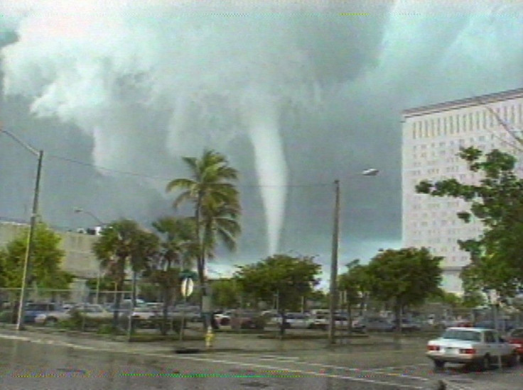
5. Condensation funnel. The iconic shape of a tornado. It is a funnel cloud until it reaches the ground, then it is deemed a tornado. It consists of water droplets. A tornado is a whirling updraft with rotating winds of 110 mph to 200 mph.
To become a storm spotter, visit www.skywarn.org.
© Copyright IBTimes 2024. All rights reserved.
- MOST POPULAR IN Society


