

Tropical Storm Flossie Tracks Toward Hawaii As Residents, Tourists Prepare For Rare Cyclone

Hawaii doesn’t see nearly as many cyclones as Americans’ other favorite tropical playground, the Caribbean region, but the Pacific island chain was preparing Sunday for an all-but-certain blow from Tropical Storm Flossie, the sixth named storm of the 2013 Pacific hurricane season.
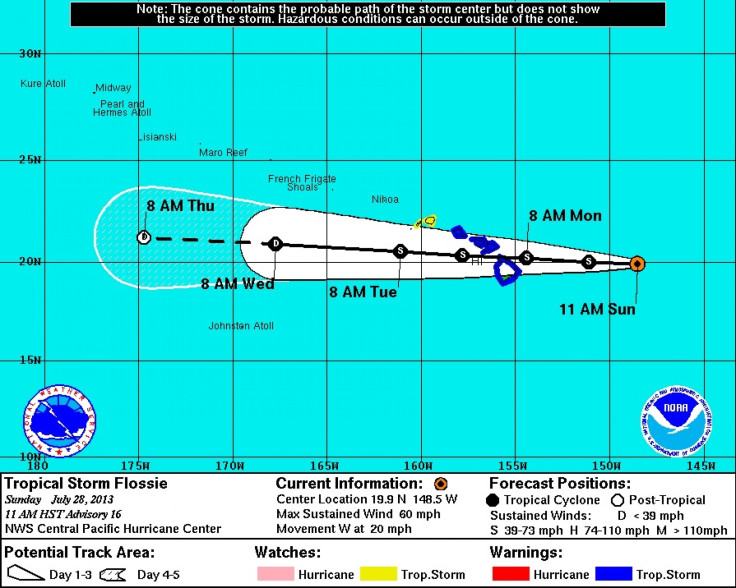
According to the latest advisory from the Central Pacific Hurricane Center in Honolulu, Tropical Storm Flossie was about 430 miles east of Hilo and about 615 miles east of Honolulu with maximum sustained winds of 60 mph. The storm was moving westward at 20 mph and expected to reach the Big Island by Monday morning. Meteorologists hope drier air, increased wind shear and somewhat cooler water will have a weakening effect on Flossie before it impacts America’s 50th state.
Although Flossie is not expected to become a full-blown hurricane, forecasters say it could still pack a powerful punch. A flash-flood watch for all the Hawaiian Islands is in effect until Tuesday 6 a.m. local time. Flossie could produce rainfall totals of between 6 and 10 inches over the Big Island and Maui County, with isolated amounts of as many as 15 inches possible, mainly on the windward side, according to the National Weather Service. Oahu can expect isolated maximum amounts of 12 inches, also on the windward side. The rains could produce dangerous rip currents and high surf along the coast, in addition to life-threatening floods in the mountains, forecasters warned.
The Central Pacific Hurricane Center has issued tropical-storm warnings for Hawaii County, Maui County and the island of Oahu, including Honolulu, while Kauai and Niihau are under a tropical-storm watch.
The Hawaii Department of Land and Natural Resources closed the popular Waimanu trail and campground, Pololu trail and Ainapo trail and cabin on the Big Island Saturday in anticipation of the storm, citing “public safety concerns.” The DLNR also advised the public to avoid all forested areas on the islands beginning Monday.
“We advise that hikers, campers or hunters should avoid trails, streams and back-country areas under these conditions,” DLNR Chairperson William J. Aila Jr. said. Aila added that storm conditions such as flash floods, falling trees and landslides could trap recreationalists by blocking trails and roads.
Meanwhile, the Department of Emergency Management advised tourists to cancel any beach activities until further notice due to dangerous surf. “Beachgoers should stay well out of the water, away from peninsulas and reef areas overlooking the ocean and be aware of sudden hazardous changes in ocean behavior,” the department warned. “When a flash-flood warning is issued for your area, or the moment you realize that a flash flood is imminent, act quickly to save yourself. You may have only seconds!”
Conditions along the east-facing shores are expected to include swells between 15 and 20 feet, so residents and visitors located in flood zones were advised to prepare for possible evacuation. Those operating ocean craft were told to return to port or seek safe harbor until Flossie passes.
Only 19 tropical cyclones have tracked near the Hawaiian Islands since 1957, while only four of them maintained hurricane strength. Coincidentally, Hurricane Flossie passed just 100 miles south of the Big Island in August 2007. However, the storm had little impact, and the name Flossie was placed back on the list for a six-year rotation. If Flossie leaves a lasting impression on Hawaii this week, you can expect the name to be retired for good. If not, Hawaii may want to keep its eye on Flossie in 2019.
© Copyright IBTimes 2024. All rights reserved.
-

Gaza Health System 'Completely Obliterated': UN Expert
-

In Ecuadoran Amazon, Butterflies Provide A Gauge Of Climate Change
-

50 Years On, Vintage Vehicles To Reenact Portugal's Carnation Revolution
-

Conflicts Push Military Spending To 'All-time High': Report
-

'Thank You, America:' Zelensky And Netanyahu Applaud House Passage Of Foreign Aid Package
-

Women Journalists Bear The Brunt Of Cyberbullying
-

US Aid Shows Ukraine Will Not Be 'Second Afghanistan': Zelensky
-

Elon Musk's X Fights Australian Watchdog Over Church Stabbing Posts
-

Ukraine, Israel, TikTok: The Massive Aid Package Before US Congress
-

Eiffel Tower Loses Sparkle For Parisians Ahead Of Olympics


