

Tropical Storm Katia's Path: Could Take Aim at U.S. as Major Hurricane

Katia weakened slightly on Thursday to a tropical storm, but is expected to regain strength and emerge as a major Category 3 Hurricane over the weekend, possibly taking aim at the U.S. or Canada by mid next week.
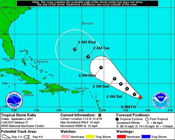
Under attack by a strong wind shear, Katia is expected to remain at or around its current 70 mph winds for the next 24 hours before rebounding to hurricane strength by Sunday.
The current models from the National Hurricane Center show Katia growing rapidly to a major Category 3 Hurricane by Wednesday with maximum sustained winds of 115 mph.
As of 8 a.m. on Friday, Katia was in the Atlantic about 705 miles east of the Northern Leeward Islands, moving northwest at 15 miles per hour, with maximum sustained winds of 70 miles per hour, or 4 miles per hour shy of hurricane strength.
On its projected path, the storm will pass well above Puerto Rico, Hispaniola, and the Bahamas, tracking closer towards Bermuda and the Mid-Atlantic coast of the United States.
It's still far too soon to say whether or not the storm will make landfall, as models are subject to hourly changes. Several forecast models indicate that the storm will likely spin back out to sea. Others have the storm heading north towards New England or the Canadian Maritimes.
If the storm does reach major hurricane status by Wednesday, it is likely that the strong winds will spin it back out to sea.
Meanwhile, the National Hurricane Center is also monitoring Topical Depression 13 in the Gulf of Mexico, which is expected to grow into Tropical Storm Lee on Friday.
Tropical storm warnings have been issued for Pascagoula, Miss. westward to Sabine Pass, Texas. This includes the city of New Orleans, Lake Pontchartrain, and Lake Maurepas.
As of 7 a.m., the storm was nearly stationary about 210 miles southwest of the mouth of the Mississippi River, with maximum sustained winds of 35 miles per hour. The storm is expected to strengthen to a tropical storm as it curves east towards the central coast of Louisiana late Sunday night.
Expecting 10 to 15 inches of rain over southern Louisiana, Governor Bobby Jindal declared a state of emergency, saying that the storm threatens to pour extremely heavy, prolonged rain over the state and cause flash flooding and high tides.
Anticipating the storm, several major international oil companies began evacuating workers from offshore oil rigs.
The National Hurricane Center is also monitoring a low-pressure system in the Atlantic roughly 450 miles south of Halifax, Canada. The system has a 60 percent chance of developing into a tropical cyclone, but likely poses no serious threat to land.
The Atlantic hurricane season typically brings 11 or 12 named storms. Lee would be the 12th. With nearly half of the season still ahead, 2011 is shaping up to be the unusually busy year than was predicted.
© Copyright IBTimes 2025. All rights reserved.
- MOST READ


