

Tropical Storm Lee Brings Torrential Rains to Mexico’s Northern Coast
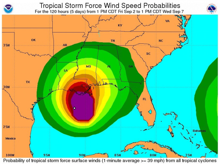
The large storm that was churning in the Gulf of Mexico grew as Tropical Storm Lee, on Friday, is bringing up to 20 inches of rains to parts of the northern coast of the Gulf of Mexico, according to the National Hurricane Center in Miami.
The U.S. is on high tropical cyclone alert, as Tropical Storm Lee strengthens and is forecast to inundate the Gulf Coast including New Orleans with possible severe flash flooding, and Hurricane Katia forces U.S. East Coast residents to keep a keen eye on that storm's strengthening and path.
Lee was expected to bring heavy rain on the central Louisiana coast on late Saturday and turn east toward New Orleans.
The National Hurricane Center issued another update on Friday stating that the storm was located about 170 miles southeast of Cameron, La., or 180 miles west southwest of the mouth of the Mississippi River, with winds of 45 miles per hour. Its present speed is 3 miles per hour.
Residents who have faced other killer hurricanes like Betsy, Camille and Katrina didn't expect that Lee to live up to that legacy.
It's a lot of rain. It's nothing, nothing to Katrina, Malcolm James, 59, a federal investigator in New Orleans, who lost his home after levees broke during Katrina in August 2005 and had to be airlifted by helicopter, told National Public Radio.
Slow-moving systems like this bring flooding rainfall, which is could be the primary threat from Lee at this time.
Besides flooding rain, there could be at least some coastal flooding, high surf and rip currents, which are a vastly underrated killer, according to The Weather Channel.
Tropical cyclones form tropical storms when winds exceed 39 miles per hour (63 kilometers per hour). They turn into hurricanes when winds top 74 miles per hour. Lee would be the 12th named storm of the busy 2011 Atlantic hurricane season.
Louisiana Gov. Bobby Jindal and the mayor of New Orleans, on Thursday, have declared a state of emergency because a tropical disturbance in the Gulf of Mexico - with increasingly organized thunderstorm activity - could drench the state with up to 20 inches of rain over the weekend.
The Bureau of Ocean Energy Management, Regulation and Enforcement (BOEMRE) on Friday said that personnel have been evacuated from a total of 169 production platforms, which is equivalent to 27 percent of the 617 manned platforms in the Gulf of Mexico.
Strong winds and heavy rain have already began lashing down on Louisiana and Mississippi Gulf Coast residents on Friday afternoon as Lee lurches closer to New Orleans.
The bottom line is the longer it stays, the more rain we're going to get, Ken Graham of the National Weather Service forecasting office in Slidell, La., said in a conference call with reporters.
There have been drought conditions reported during the summer in the South and the wet weather may come as a relief.
However, with so much water pouring down at once on the state, and with tides running two to five feet above normal, the water that will pile up in inlets, rivers and bays may have nowhere to drain, and could result in widespread inland flooding, forecasters said.
© Copyright IBTimes 2025. All rights reserved.
- MOST READ


