

Tropical Storm Maria on Path toward Leeward Islands, Nate Takes Aim at Mexico

Tropical Storm Maria is churning away out in the Atlantic as she lumbers on a path toward the Leeward Islands and possibly, the U.S. East Coast.
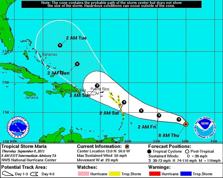
Maria is located roughly 760 miles east of the Windward Islands with maximum sustained winds of 50 mph, according to an 8 a.m. EDT alert from the National Hurricane Center in Miami. At present, the storm is moving west at 23 mph and it is expected to continue in that direction before making a slight turn to the west-northwest on Friday.
If the storm follows its present course, the center will approach the Leeward Islands by Friday night.
A tropical storm watch is in effect for the Leeward Islands of Antigua, Barbuda, Montserrat, Nevis and Saint Kitts. The watch means that tropical storm conditions are possible within 48 hours.
Interests in the Virgin Islands and Puerto Rico were advised to monitor the storm as well.
Maria is not expected to become a hurricane anytime soon. In fact, surface observations and satellite imagery suggest that Maria could be in the process of degenerating into a tropical wave. However, at present, tropical-storm-force winds extend outward up to 115 miles from the storm center.
If Maria does not degenerate, there is a chance that it could follow a similar path as Hurricane Irene did in late August. However, as the paths of tropical cyclones are subject to hourly changes, it's still far too early to say what, if any, impact Tropical Storm Maria will have on the U.S. coast.
Elsewhere in the Atlantic, Hurricane Katia passed between Bermuda and the East Coast of the United States Thursday morning. Forecast models show the slowly weakening storm heading out to sea back across the Atlantic north of the United Kingdom.
However, the National Hurricane Center warns that large swells generated by Katia are due to affect most of the East Coast through the weekend, creating potentially life-threatening surf and rip current conditions.
A third named storm has developed in the Gulf of Mexico. Tropical Storm Nate, located just north of the Yucatan Peninsula, is currently meandering over the bay of Campeche. According to the 7 a.m. EDT alert from the National Hurricane Center in Miami, Nate had maximum sustained winds of 45 mph and was expected to strengthen over the next 48 hours before making an erratic eastward or northeastward turn into Central Mexico.
The Atlantic hurricane season typically brings 11 or 12 named storms. Tropical Storm Nate is the 14th. With nearly half of the season still ahead, 2011 is shaping up to be the unusually busy year that was predicted.
© Copyright IBTimes 2025. All rights reserved.
- MOST READ


