

Water On Mars: New Found River Deposits Point To Complex Water Systems
New findings in the Aeolis Dorsa region of Mars are the densest river deposits seen on Mars. These deposits gather data of water that flowed on the surface of Mars over 3.5 billion years ago
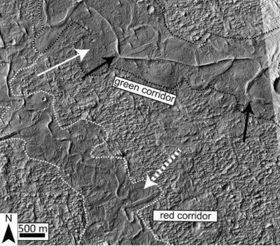
The deposits were seen through satellite images mainly because of a process called "topographic inversion." This is where the deposits from the river systems that flowed across the surface of the red planet are found. The low topography channels are exhumed, meaning they caked over time, with the flowing water to form ridges. These ridges could be studied to better understand the evolution of our neighbor.
The high-resolution images that are obtained from the cameras in the orbiting satellites were studied along with the topographical data of Mars by Benjamin T. Cardenas and colleagues from the Jackson School of Geosciences.
They identified fluvial deposit stacking patterns. They also developed a method to measure the direction of the river based on the ridges and their pattern. They saw that the sediment pattern changes as the coastline morphed. What this means is, the data could help us understand the progress of water on the planet and see what kind of life may have existed there.
The findings could help establish the incised valley system, much like Earth, that existed on Mars. The valley would have filled up and ebbed away with the rise and fall of eustatic sea level, much like on Earth. This could better help connect the evolution cycles of the two planets together to see if any links can be made.
The team observed a similar rise and fall in water levels of the paleo-valleys of Mars that they recently stumbled upon. These patterns point toward multiple cases where the water level on the planet, along these ridges, rose and fell. The ridges went up to 50 meters in height and were seen to match the scale of eustatic sea level changes on Earth.
The fluctuating levels and the current absence of water could establish a link between our planet and Mars. The patterns point toward a complex ebb and flow. The shifts in coastline also point toward a constant flooding. All these links could prove determinant in the study towards understanding the evolutionary cycle of Mars.
The large water level fluctuations and coastline movements are demonstrated in these river deposits. This could point to a very stable and channeled downstream water body which cannot be the product of random hydrological events but a progressive evolution of water bodies.
The lack of water in valleys across earth now compared to the lack of water on Mars and the comparative data from different factors like height and changes in direction of flow could establish a similar evolutionary timeline between the two planets.
The mounting pile of complex data on Mars available constantly points to factors that could sustain life. Developments like this often add up over time to conclude and help facilitate theories. The colonization of Mars is now simply a pipe dream. But with the growth of private space companies, a sense of expectation has associated itself with the red planet.
© Copyright IBTimes 2024. All rights reserved.
- MOST POPULAR IN Technology


