

Will Nor'easter Athena Deliver Second Punch To East Coast?
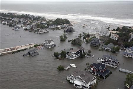
First Sandy, now Athena. A nor'easter is bearing down on the East Coast, poised to dump more high winds, rain and flooding on an area still struggling with lingering hurricane damage.
Only about an inch of rain is forecast, though the nor'easter will bring winds (out of the northeast, naturally) of 25 to 40 miles per hour, with gusts peaking between 55 and 65 miles per hour. A storm surge between 3 and 5 feet is also predicted as Athena sweeps through.
Before this year, winter storms were not typically given names, but the Weather Channel decided to implement a naming policy to raise awareness about potentially dangerous storms. The National Weather Service, however, still does not refer to nor'easters by name.
New York City has already taken numerous precautions to prevent Athena from suckerpunching vulnerable areas in the region. All City parks are closed, and more than 600 nursing home residents at four facilities in the tempest-tossed Rockaways have already been evacuated.
Early Wednesday morning, winds had already picked up in Atlantic City, N.J., which also received a bit of rain. Athena's storm surge has already reached more than 2 feet in Atlantic City and just below 2 feet in New York City. Meteorologists forecast that coastal areas heavily damaged by Sandy could see a storm surge of between 2 and 3.5 feet, accompanied by waves up to 20 feet high.
While there are no mandatory evacuation orders in place in New York City, the mayor's office is encouraging New Yorkers living in low-lying areas to shelter with friends and asking all residents to avoid driving after 5pm on Wednesday.
“Because Hurricane Sandy weakened trees and caused extensive damage and debris, the predicted wind speeds present an increased risk of more downed trees and tree limbs, as well as windblown debris,” the city said in a statement. “All New Yorkers are urged to stay indoors during inclement conditions.”
In New Jersey, residents living in the low-lying water front areas of Brick Township were told to evacuate by 6 p.m. on Tuesday.
The storm is expected to dump snow from Maryland to New England, and linger until Thursday. Athena is also bringing some truly chilly temperatures along for the ride.
“Additional cold air will be drawn in along the western flank of Winter Storm Athena Wednesday into Thursday,” the Weather Channel forecasted. “Coupled with the strong winds, this November nor'easter will feel raw.”
But Athena's wrath could have been worse, according to Weather Underground meteorologist Jeff Masters.
Winter storm Athena “is now forecast to be weaker and move farther offshore than originally forecast, resulting in lower impacts to the New Jersey and New York coasts than originally feared,” Masters wrote on Tuesday.
Flooding will also be reduced because the storm is hitting in between the new and full moons, causing lower tides. Athena is also not going to be able to tap into a large swath of Arctic air, which will limit her snowfall to between 1 and 2 inches, according to Masters.
Masters predicted that Athena would cause about 50,000 new power outages, adding to the current 676,000 people that are still without electricity in the wake of Hurricane Sandy – a large number, but vastly down from a peak of 8.5 million customers.
“While the storm will slow down recovery efforts from Hurricane Sandy, this is a pretty ordinary Nor'easter of the type the Northeast sees several times per year, and will not cause major damage,” Masters wrote.
© Copyright IBTimes 2025. All rights reserved.
- MOST POPULAR IN Science


