Another Polar Vortex? What To Expect As ‘Dangerous’ Winter Weather Descends On US

A mass of frigid air moving down from the north will plunge much of the U.S. into Arctic conditions this week, with the cold rivaling that experienced during last year’s so-called polar vortex. The winter déjà vu is expected to bring subfreezing temperatures – in some areas, as low as 40 degrees Fahrenheit below zero – to nearly every corner of the country east of the Rocky Mountains as well as snarling snow and strong winds to parts of the Northwest and Northeast.
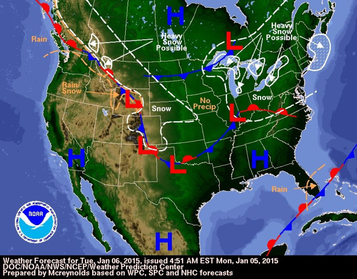
"This is going to be a big cold outbreak, pretty windy as well," National Weather Service meteorologist Paul Kocin told the Associated Press. "It's going to drive all the way down South." Weather experts have said the cold conditions are typical of U.S. winters but could bring below-average temperatures for this time of year. The cold will slam the Upper Plains first on Tuesday before moving into the Midwest by midweek and then the Northeast on Thursday, according to NBC News. Meteorologists warn of dangerous conditions in the Plains, Midwest and the East Coast when the cold rush hits.
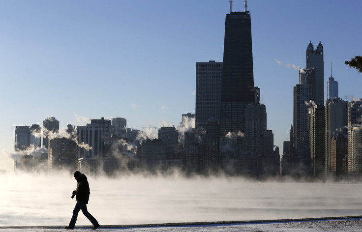
The effects of the Arctic blast, the coldest weather of the season yet, have already been felt in New Hampshire and Illinois. Officials issued a winter weather advisory for Chicago over the weekend following falling temperatures and a snowstorm that dumped several inches over northern Illinois. More than 230 flights out of O’Hare International Airport were canceled Sunday, the Chicago Tribune reported. And more than 800 flights were canceled or delayed across the country.
In New Hampshire, dozens of vehicles were involved in two pileups along Interstate 93 on Friday after powerful snow squalls brought whiteout conditions to the area. Several minor injuries were reported.
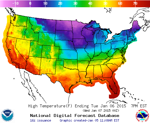
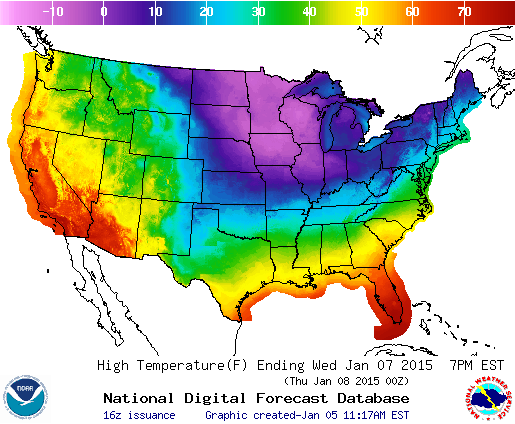
The brunt of this week’s cold rush is slated for Thursday. Meteorologists expect temperatures to dip below freezing as far south as Atlanta and New Orleans, according to the National Weather Service. Wind chills across the Northern Plains and Ohio River Valley will bring temperatures of minus 25 to minus 45 degrees Fahrenheit. Minneapolis and Chicago could see temperatures as low 50 degrees below zero. In those conditions, exposed skin can succumb to frostbite, a serious injury in which skin tissue is permanently damaged due to the cold, in just 10 minutes.
"People need to be careful because of the frostbite threat," Kevin Roth, lead meteorologist at the Weather Channel, told NBC. "It's going to be bitter. Kids heading out to the school bus need to make sure they are wrapped up warm and have their skin covered up. It will be the coldest weather most people have experienced this winter."
Chicago, Detroit and Cleveland can expect some light snow on Monday. New York City and Boston are liable to similar conditions on Tuesday as high temperatures there will linger in the 20s.
The polar vortex is a large pocket of cold air that hangs above the northernmost region of the Northern Hemisphere during winter. The term became widely used in January 2014, when Arctic air slumped into Canada and brought record-breaking temperatures, but it is “not a recently discovered phenomenon,” Bernie Rayno, a senior meteorologist at AccuWeather.com, said in November. “In fact, it has been talked about in the meteorological world for decades," he said.
Now and then the vortex can get pushed south over Canada and the U.S., bringing subzero temperatures that can last several days. This southern shift happens when the vortex becomes weak, allowing powerful, high-pressure systems from the West to displace cold air over the Arctic.
The term “polar vortex” has been used recently to describe several sudden drops in winter temperatures in the U.S., but experts say it is often misused. Most cold air outbreaks are caused by a jet stream that travels from west to east across Canada and the U.S., according to the Weather Channel. This stream hangs about 4 to 9 miles above the surface of the earth and pulls Arctic air down from the pole. The polar vortex, by contrast, is located roughly 12 miles above the ground and typically remains near the North Pole.
© Copyright IBTimes 2026. All rights reserved.
- MOST POPULAR IN Science