

Are ‘Frankenstorms’ Like Sandy The New Norm Thanks To Climate Change?
Hurricane Sandy is poised to slam into the East Coast and the history books this week. And scientists say that climate change may make storms like Sandy the new normal.
“It's a matter of probabilities,” says Jeff Masters, a meteorologist at Weather Underground. “When you add more heat energy to the ocean, you have more energy available to power strong storms. We've now made it possible to have something we've never seen before.”
The bottom line: a warmer climate means that bigger and later hurricanes like Sandy are more and more likely.
“We do know that if you heat up the oceans, you tend to increase the length of hurricane season and have storms earlier and later in season,” Masters said.
Most scientific observations show this effect appears to be taking place in the Atlantic, correlated with rising ocean temperatures. In past decades, late October hurricanes were practically unheard of, but they are become more common in recent years, according to Masters.
Later hurricanes mean that storms are more likely to interact with winter systems, creating hybrid “Frankenstorms” like Sandy.
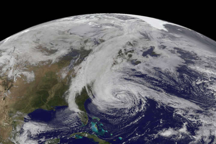
One of the more unusual aspects of Sandy's track is the sharp turn the storm is taking. Instead of heading out to the Atlantic, a large high pressure system hovering over Greenland is forcing Sandy back towards New Jersey, where she is expected to make landfall on Monday night. That blocking system, called a ridge, is a product of the powerful jetstream that flows high in the atmosphere above North America.
“The jet stream doesn't flow straight west to east. It has bulges and loops,” Masters explains.
When the jetstream bends southward in a U-shape, that creates an area of low pressure called trough. Bent the other way, the jetstream forms an area of high pressure called a ridge. These loops and bulges may be another area that is affected by climate change.
The whole reason the jetstream exists is because of the temperature difference between the Earth's equator and poles. Record-breaking losses of Arctic sea ice mean that instead of being covered with reflective white ice, the darker ocean water is exposed and can store heat energy, reducing the temperature gradient and causing a feedback loop that ends up melting more ice.
This 'Arctic amplification' is thought to play a role in many kinds of extreme weather patterns. Scientists think that a reduced temperature difference between the equator and the Arctic may weaken the winds high in the atmosphere, causing a “kind of meandering looping behavior in jetstream,” Masters says.
The waviness in the jetstream can have broad effects. According to Rutgers University
researcher Jennifer Francis, an unusually deep trough hanging over the U.S. East coast and Western Europe during the 2009-2010 and 2010-2011 winters brought snow-storms and frigid cold. And while broad northward-bulging ridges in the jetstream may have gifted the Northeast an unseasonably warm winter in 2011-2012, a big ridge doesn't always spell clear skies, as Sandy shows.
“While it’s difficult to point the finger at Arctic amplification in causing any of these weather events, they are the types of phenomena that are expected to occur more frequently as the world continues to warm and the Arctic continues to lose its ice,” Francis wrote in March.
© Copyright IBTimes 2026. All rights reserved.
- MOST POPULAR IN Science


