

El Niño Has Arrived But It Won't Solve The California Water Shortage

El Niño is officially upon us. U.S. climate experts recently confirmed the phenomenon’s presence after months of warming water temperatures in the Pacific Ocean. Conditions likely will stick around this year, possibly bringing brief bouts of rain to bone-dry California and setting up 2015 to be one of the hottest years on record, meteorologists say.
“We expect the El Niño-type pattern in the Pacific to hold right through the summer and into the fall,” Dan Leonard, a senior meteorologist with the Weather Company's WSI Division in Andover, Massachusetts, said by phone.
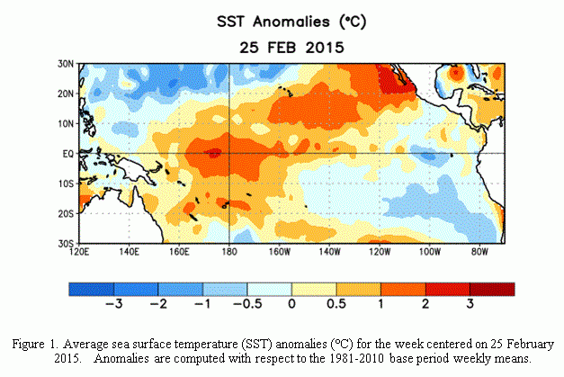
The National Oceanic and Atmospheric Administration (NOAA) declared El Niño’s arrival last week after Pacific sea surface temperatures persistently warmed by more than 0.5 degrees Celsius (0.9 degrees Fahrenheit) above normal -- the marker of a “weak” El Niño. While the phenomenon isn’t likely to morph into a stronger event, it still could affect weather in parts of the Northern Hemisphere and amplify global surface temperatures, federal forecasters said in an advisory.
The announcement upholds what most weather experts already have seen. “We’ve been in a weak El Niño state for about four to five months,” Leonard said, adding that the NOAA declaration “is like when the National Bureau of Economic Research declares an official recession, but everybody already knows we’ve been in one.”
During an El Niño, warm equatorial waters that pool near Asia and Australia are propelled toward the Americas by shifting winds and currents. The west-to-east commotion has the effect of raising the ocean’s overall surface temperature, which in turn can elevate air temperatures and alter precipitation patterns. (La Niña is the opposite phenomenon, characterized by unusually cold Pacific temperatures.)
Often in an El Niño event, the warm ocean water flings more moisture into the air, increasing the potential of heavy rains and flooding along the western coast of the Americas. In recent months, drought-stricken California has seen a slight uptick in precipitation.
The current El Niño could still bring replenishing rains to the state, though the window for wetness is rapidly closing, said Tom Downs, a meteorologist at WeatherBell Analytics in New York City. California’s rainy season lasts only through April; from May until October, the chances of rainfall are close to zilch.
“Any welcome drought relief would need to come from now till early May, before the summer heat starts to build and the rainy season ends,” Downs said. Even so, “We don’t expect to see widespread rainfall [in California]. We don’t expect deficits to be reduced whatsoever this year.”
El Niño will likely have more of a dramatic effect on global temperatures this year, however, in large part because it’s happening alongside a separate phenomenon: the Pacific Decadal Oscillation (PDO).
In the last year, a “positive” PDO event has developed in the Northern Hemisphere. Warm tropical waters are forming a horseshoelike pattern in the eastern Pacific, pushing north to Alaska and south to the equator. Meanwhile, a pocket of cooler sea-surface temperatures is building near Hawaii and Japan. (From about 1999 to 2013, the PDO was in a cool, or “negative,” phase.)
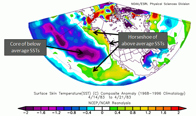
The positive PDO may have helped make 2014 the warmest year on record, said Kevin Trenberth, a climate scientist at the National Center for Atmospheric Research in Boulder, Colorado. Global average temperatures rose by 0.68 degrees Celsius (1.24 degrees Fahrenheit) above the long-term average, NOAA and NASA scientists reported in separate analyses earlier this year.
With the combined PDO-El Niño effect, “the prospects are that this [Earth-warming] is going to continue in 2015,” Trenberth said.
The Pacific Ocean phenomena are adding to the heat created by man-made global warming, which is caused by burning fossil fuels for energy and slashing and incinerating trees, among other factors. Since 1880, Earth’s average surface temperature has warmed by about 0.8 degrees Celsius (1.4 degrees Fahrenheit), according to NASA. Most of that warming has happened in the past three decades.
Trenberth said that, if mapped on paper, increases in global warming would look more like a staircase, instead of a gradually elevating line. The flipping between positive and negative PDO events, or a warm El Niño or cold La Niña, creates some fluctuation and natural variability in the overall temperature of the planet, from year to year.
“Underlying everything is this tendency for the globe to actually warm,” he said. “We go through phases, and things get stalled on a stair [during cold phases]. But now in 2014, we’re edging up to the next stair, and maybe we don’t go back down again. Global mean temperatures end up being higher from here on out.”
© Copyright IBTimes 2025. All rights reserved.
- MOST POPULAR IN Business


