

Hurricane Laura Aftermath: Satellite Images Show Flooding, Blackouts

KEY POINTS
- Hurricane Laura was among the strongest hurricanes to make landfall in US
- Satellite images captured the damages it inflicted
- Large areas are flooded while thousands remain without power and running water
Hurricane Laura was among the strongest hurricanes to make landfall in the United States and satellite images captured the kind of damage that it left.
It was last week, Aug. 26, when Hurricane Laura made landfall in the United States, causing significant damage in Louisiana and east Texas. Heavy rain and storm surges that ranged from 3 to 5 meters (9 to 15 feet) inundated coastal lands with floodwater, while powerful winds destroyed homes and even downed trees and power lines.
NASA Earth Observatory shared images of the affected areas, showing the kind of damage that the hurricane brought upon Louisiana. The first pair of images is of the coastal lands around the towns of Cameron and Creole in Louisiana, as captured by the Operational Land Imager (OLI) instrument aboard the Landsat 8 satellite. They are false-color images wherein the green marks vegetation, the clouds are cyan and the black and navy blue areas are water.
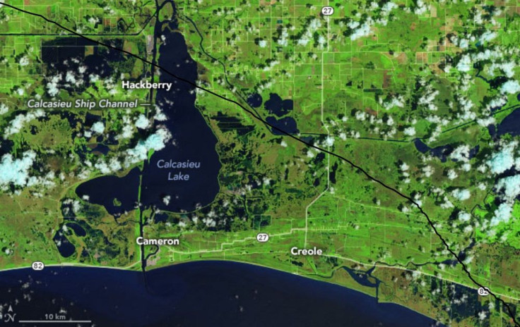
The image above, taken on Aug. 13 before the hurricane, shows the normal situation in the area, with Calcasieu Lake highlighted close to the center of the image. In the image below, which was taken on Aug. 29, large patches of what used to be bright green had turned into patches of dark blues and black, showing the massive flooding present in the area. The flooding can be observed even far from the Lake and the coast.

Another pair of satellite images, this time captured by the NOAA-NASA Suomi NPP satellite, shows the damage that the strong winds inflicted in the city of Lake Charles and its surrounding areas. These are nighttime images of the area captured by the Visible Infrared Imaging Radiometer Suite (VIIRS) instrument aboard the satellite and they show the difference between the early morning hours of Aug. 3 and Aug. 31.
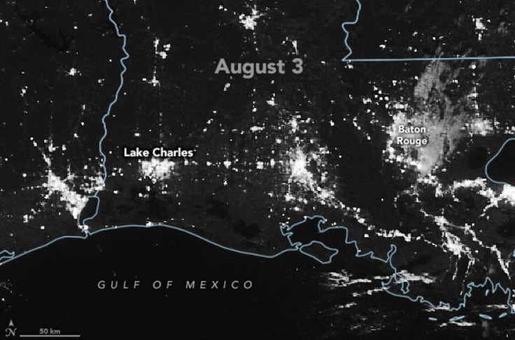
Compared to the Aug. 3 image, the Aug. 31 image shows significantly fewer lights in the area, particularly in Lake Charles.
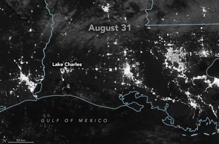
As of the afternoon of Aug. 31, hundreds of thousands of people affected by Hurricane Laura are still without electricity while many are also without access to running water.
"Homes and businesses are destroyed, some areas are still unreachable, heavy debris is blocking roads, and hundreds of thousands of people are without power and water," the Red Cross said in a statement. "In Louisiana, many parishes still face evacuation orders and it could be months before power is restored."
To date, The Associated Press reports 19 deaths in Texas and Louisiana linked to the storm. With damage assessments only beginning and evacuees spread across Louisiana and Texas to prevent them from being close together in group shelters due to the ongoing pandemic, authorities are warning residents that the road to recovery will likely be a long one.
© Copyright IBTimes 2025. All rights reserved.
- MOST POPULAR IN Science


