

Mars Craters With Leaf-Like Structures, Black Dune Field Captured In ESA Photos
KEY POINTS
- ESA's ExoMars captured new images of Mars
- The images show Mars diverse geological features
- The new photos of the Red Planet were taken after the spring equinox
The European Space Agency’s (ESA) ExoMars orbiter captured new images of the Red Planet’s surface. The photos show some of the geological features that can be found in the craters of Mars.
The images were captured using the Color and Stereo Surface Imaging System (CaSSIS) of the ExoMars Trace Gas Orbiter (TGO), the robotic probe launched by the ESA through a collaborative project with the Russian space agency Roscosmos.
The TGO entered Mars’ orbit in 2016. Since then, it has been observing the Red Planet’s surface from its orbit.
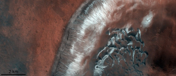
The latest images were captured by the TGO shortly after the spring equinox on Mars. One of these shows part of an impact crater inside the larger Green Crater, which can be found in the Argyre quadrangle in the Red Planet's southern hemisphere. It showcases the diverse geological features of the crater.
TGO’s photo features an almost black dune field surrounded by Mar’s distinct red soil. Some parts of the ground are covered with ice. The patches of ice on the surface show traces of the recent season on Mars, ESA noted.
“The image was taken just after the spring equinox in the southern hemisphere of Mars, when the southernmost part of the crater (to the right) was almost completely free of ice while the northern part (center) was still partially covered,” the ESA explained in a statement.
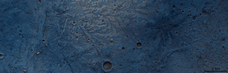
Another photo features the leaf-like structures on the surface of the Antoniadi impact crater, which is located in the Syrtis Major Planum region in Mars’ northern hemisphere.
The photo shows vein-like structures at the bottom of the crater. The ESA stated that these natural structures were most likely formed by networks of rivers that once flowed across the Martian surface. As the networks eroded, they left behind traces of the rivers.
“These structures, evidence of ancient river networks in this region, protrude from the surface, unlike channels, which are usually sunken in the surface,” the ESA explained. “This is because the channels were filled with harder material – possibly lava – and over time the softer rocks surrounding these branching channels have been eroded, leaving an inverted imprint of this ancient river system.”
© Copyright IBTimes 2025. All rights reserved.
- MOST POPULAR IN Science


