

NASA Shares Mount St. Helens’ Satellite Image On 40th Anniversary Of Eruption

KEY POINTS
- May 18, 2020, marks the 40th anniversary of Mount St. Helens' devastating eruption
- NASA Earth Observatory shared the most recent Landsat-8 image of the volcano
- The eruption sparked major advances in volcanology and monitoring
NASA Earth Observatory shared a recent satellite image of Mount St. Helens, Washington, on Monday, the 40th anniversary of its eruption. The cataclysmic event that occurred May 18, 1980, was dubbed the deadliest eruption in United States' history.
Mount St. Helens had erupted after months of earthquakes and smaller explosions. The blast was so massive, it leveled millions of trees and caused the deaths of 57 people, some of whom were outside the established danger zone.
Satellites have allowed scientists to monitor Mount St. Helens for the past decades. In fact, in 2017, on the 37th anniversary of the eruption, the National Weather Service in Seattle shared a series of images acquired by the Geostationary Operational Environmental Satellite-3 in 1980.
Here's the visible satellite loop of the Pacific Northwest 37 years ago today - as Mount St. Helens erupted. #wawx pic.twitter.com/K2t1gUi9Ho
— NWS Seattle (@NWSSeattle) May 18, 2017
This year, on the 40th anniversary of the eruption, NASA Earth Observatory shared recent images of the volcano, showing how it has recovered since.
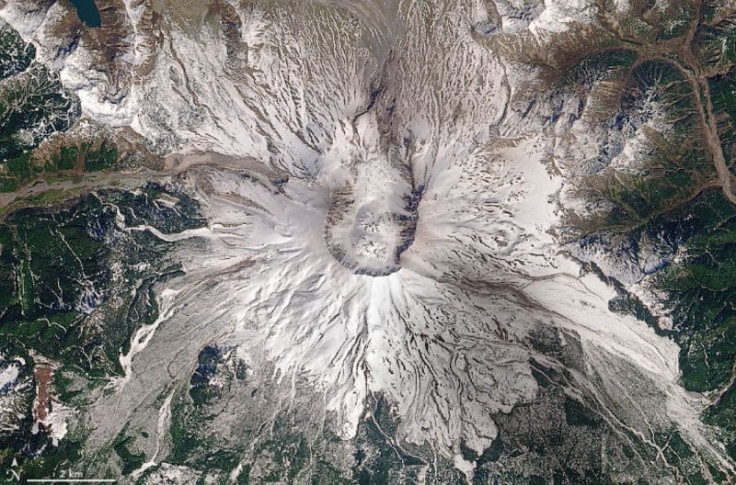
The "image of the day" for May 18 was taken by the Landsat 8 satellite last April 17, 2020, and it showed Mount St. Helens covered in seasonal snow even if it was already spring. According to NASA Earth Observatory, the ice will melt by August.
It is Landsat 8's most recent cloud-free image of Mount St. Helens.
An image pair shared by the agency showed Mount St. Helens on June 17, 1984, just years after the eruption, and more recently Aug. 20, 2013. The image showed the scale of the devastating eruption and how greenery had returned to the volcano years later.
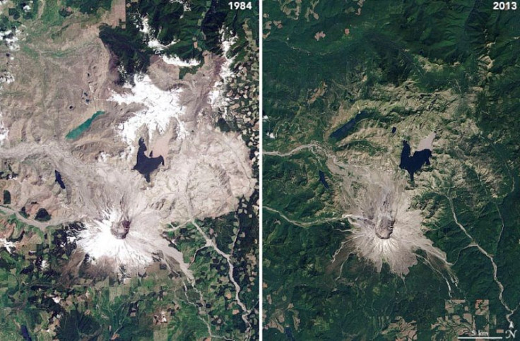
"Satellite images acquired in the days around the eruption on May 18, 1980, helped scientists understand the event; images acquired over the past four decades have given them insight into how a landscape recovers," NASA Earth Observatory noted.
According to the United States Geological Survey (USGS), the Mount St. Helens eruption triggered the advances in volcano science and led to the technology that exists today, especially since it was the first large explosive eruption scientists were able to observe using modern volcanology.
"Since the eruption of Mount St. Helens, volcano monitoring has evolved from placing a few scientific instruments on a volcano’s flanks to a broader integrated network of monitoring devices that measure earthquakes, deformation and volcanic gases, and can detect eruptions or changes on the Earth’s surface from space," USGS added.
© Copyright IBTimes 2025. All rights reserved.
- MOST POPULAR IN Science


