

Nighttime Satellite Images Show Change In Hubei Amid Coronavirus Lockdown

KEY POINTS
- Satellites took nighttime images of Hubei in January and February
- Lights in Hubei were much dimmer after the coronavirus-related restrictions were placed
- Such images help provide a better understanding of human settlements and activities
Nighttime satellite images of Hubei province illustrate the difference in the way that people were living and moving before and after the coronavirus-related restrictions were placed.
China began barring people from entering or leaving Wuhan, the epicenter of the coronavirus epidemic, on Jan. 23. At the time, the usual hustle and bustle in the area quickly halted and activity nearly completely ceased.
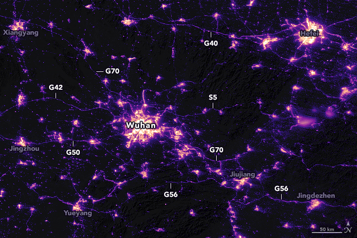
Previous satellite images have shown that this cease in activity caused dramatic drops in pollutants over hard-hit places such as China and Italy. Using nighttime satellite images taken by the Suomi NPP satellite 16 days apart at exactly the same angle, researchers from NASA's Goddard Space Flight Center and the Universities Space Research Association (USRA) also detected clear signs of the activity change around Hubei Province.
The first image was taken last Jan. 19 still shows fairly normal activity, with the areas marked with "G" and "S" indicating the busy highways littered with vehicle lights. Wuhan can also be seen brightly lit at the center of the image.
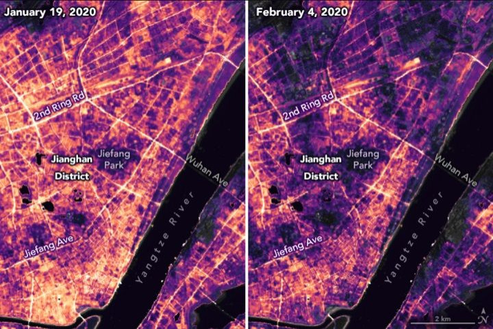
In a second image taken on Feb. 4, after the restrictions were already placed, there are almost no highway lights, indicating the stark change in travel activity. Wuhan is also markedly dimmer than before.

Another image shows the pronounced difference in the commercial Jianghan District in Wuhan as well as in the nearby residential areas. The side-by-side image shows how the bright lights that were observed in Jan. 19 were significantly dimmer by Feb. 4.
"The lights provide a different perspective on human settlements. We are not just looking at where the roads are; these images are telling us when and if the roads are being used. We are looking at human activities," director of the Earth from Space Institute at USRA, Miguel Román, said. "We have been studying cities around the world and how they grow and change. Are they becoming more or less sustainable and livable? How do they consume energy? When, where, and how do people move and why?"
This week, China announced that it will end the two-month lockdown in Hubei as the outbreak in the area has since been under control. It is likely that nighttime in Hubei will soon return to its original, bright state.
© Copyright IBTimes 2025. All rights reserved.
- MOST POPULAR IN Science


