

Scarborough Shoal: The Strategic Reef At The Center Of China-Philippine Tensions


KEY POINTS
- Both countries have made strong territorial claims over the reef
- China seized Scarborough Shoal in 2012 following a 10-week standoff with the PH navy
- The shoal is packed with marine life and is said to be strategic due to its location
- Tensions escalated last month after the Chinese installed a floating barrier in the area
Scarborough Shoal, the disputed ring of reefs in the South China Sea, has once again gained international interest amid escalating tensions between its two claimants, China and the Philippines.
What are the claimants saying?
China claims that the disputed shoal was already mentioned in Chinese historical texts as far back as the Yuan Dynasty (13th century). The island was later reportedly mentioned in China's Genglu Bu, or the Manual of Sea Routes that Chinese fishermen supposedly wrote more than 600 years ago. Since 1935, the reef's name has changed twice before it became Huangyan Dao in 1983.
In its latest map published late last month, China expanded the terrtory that it claimed under its infamous 9-dash line with a new 10-dash line. The map now includes parts of the east side of Taiwan and India's Arunachal Pradesh and the Aksai Chin plateau, which is controlled by China but India is disputing.
The Philippines, on the other hand, has largely based its claims on the provisions of the United Nations Convention on the Law of the Sea (UNCLOS) and its 2016 international arbitral victory that overwhelmingly invalidated China's claims in the South China Sea.
The mother of all PHL map: The more than 300 yr. Murillo-Velarde 1734 Map,1st time to be presented in PH |@jpsoriano pic.twitter.com/KZTXm6v7In
— GMA Integrated News (@gmanews) May 4, 2017
However, Manila has, in recent years, also started basing its claims on historical maps, in particular the 1734 Velarde Map of the country drawn by Jesuit Father Pedro Murillo Velarde that calls Panatag Shoal "Panacot" and the 1784 Map of the Pacific Ocean between the Coast of California and Mexico and Japan, Philippines, and the Coast of China that calls Bajo De Masinloc "B. Masinloc."
The disputed shoal is also portrayed in the following maps by late-19th century Spanish sources:
- 1860 Borneo, Iles de la Sonde, Celebes, Moloques et Philippines (R. Scarborough)
- 1875 Carta General el Archipelago Filipino al Mando del Capitan de navio D. Claudio Montero y Gay (B. Masingloc/Scarborough)
- 1879 Derrotero del Archipelago Filipino (Marzingola y Panacot en la carta del P. Murillo)
The Philippines was occupied and ruled by Spaniards for 333 years before they left the country in 1898.
Aside from references of Bajo De Masinloc in Spanish maps, some U.S. maps also showed the disputed shoal as being within the Philippine archipelago, including the 1899 Mapa General, Islas Filipinas.
The political boundaries of the Philippines at the time of the Revolution against Spain, 1896. See provincial names and boundaries. ("Islas Filipinas Mapa General No 2, Observatorio de Manila 1899") #BonifacioDay pic.twitter.com/a4vvknZysd
— Manuel L. Quezon III (@mlq3) November 30, 2019
What does the UNCLOS say?
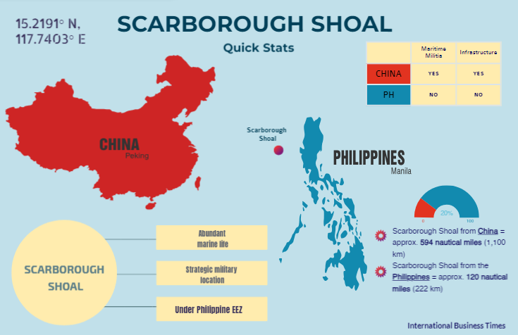
The triangular chain of reefs is located some 222 kms (120 nautical miles) from Luzon, Philippines, and around 1,100 kms from China's Hainan Island. Manila has repeatedly said that Scarborough Shoal, called Bajo De Masinloc or Panatag Shoal in Philippines, is part of its exclusive economic zone (EEZ).
According to Articles 55-57 of the UNCLOS, a country's EEZ "shall not extend beyond 200 nautical miles from the baselines from which the breadth of the territorial sea is measured." Based on that, Scarborough Shoal is within the Philippines' EEZ.
Within a state or country's EEZ, it has sovereign rights to explore, exploit, conserve and manage the area's natural resources, the UNCLOS states. The state can also establish and use artificial islands, installations and structures and conduct marine scientific research.
What triggered the years-long dispute?
Before the recent exchange of fiery warnings over the Scarborough Shoal, the two sides engaged in a 10-week standoff that started in April 2012 and ended in June 2012.
The standoff kicked off after the Philippine Navy said on April 8, 2012, that it discovered Chinese fishermen illegally harvesting rare corals, sharks and clams from Scarborough Shoal.
Following the discovery of Chinese ships collecting marine resources, the Philippine Navy tried to apprehend the vessels. However, two Chinese marine surveillance ships intervened and asked the Philippine Navy ship to leave the area.
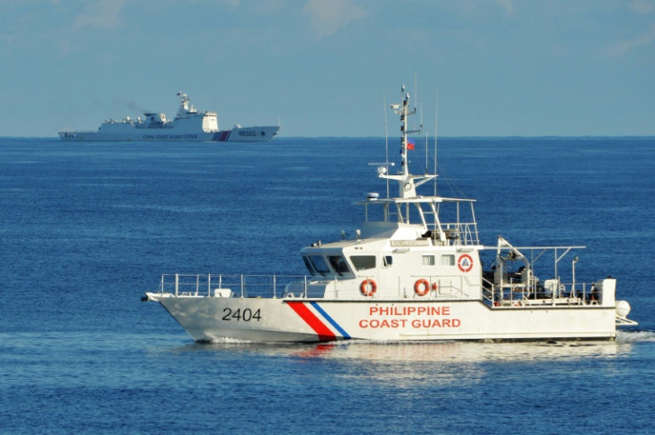
The first two days of the tense standoff ended when the Philippine Navy warship withdrew and was replaced by a smaller Philippine Coast Guard (PCG) patrol ship. However, Philippine and Chinese ships remained in waters near Scarborough Shoal for more than two months.
Then-president Benigno "Noynoy" S. Aquino III ordered all Philippine ships to leave the area on June 17, 2012, citing the beginning of the typhoon season.
Since the withdrawal of Philippine ships in 2012, China has taken control of Scarborough Shoal.
What happened with a supposed U.S.-brokered deal?
Senior U.S. and Chinese officials met in southern Virginia in June 2012 to discuss the standoff, the Financial Times reported in 2014. Then U.S. diplomat for Asia Kurt Campbell "believed" that after his meeting with China's Vice Foreign Minister for Asia Fu Ying, there was an agreement that both Manila and Beijing will withdraw from Scarborough Shoal.
In 2016, Aquino revealed that China reneged on the deal brokered by the Obama administration to resolve the standoff. "America brokered and there was an agreement for all parties to depart the shoal and finish (the standoff)," he said.
Aquino did not provide further details about the deal but he said the Philippines had been "religiously adhering" to the UNCLOS, of which China is also a signatory.
The Duterte administration, which followed Aquino's, denied that the U.S. brokered an agreement on the Scarborough standoff, saying there was "no proof" the Obama government moved to intervene by way of brokering a deal.
Former Philippine ambassador to the U.S. Jose Cuisia Jr. backed Aquino's statements, saying in 2021 that the U.S. spoke with the Chinese ambassador during the standoff for a "simultaneous" withdrawal of ships, to which Beijing reportedly agreed but did not follow through.
"I brought this to all ASEAN (Association of Southeast Asian Nations) ambassadors, and they can all confirm that China agreed to such an agreement [to pull out]," Cuisia noted.
What's so special about Scarborough Shoal?
The reefs that measure about 10 miles in width features scattered rocks and a lagoon at the center. Its most visible elevation is called South Rock.
Jay Batongbacal, director of the University of the Philippines' Institute for Maritime Affairs & Law of the Sea, in 2014 described the shoal as being "known for its significant contributions to sustaining marine life in the West Philippine Sea, and the entire South China Sea."
It is also one of the oldest known fishing grounds in the Philippines due to its massive fish stock that fishermen from China and Vietnam have also tapped in the past years.
PANOORIN: Bakit big deal ang Panatag Shoal?
— Rappler (@rapplerdotcom) September 30, 2023
So laging sinusubukang barahan ng China Coast Guard ang bunganga ng Bajo de Masinloc (a.k.a. Panatag Shoal/Scarborough Shoal) sa West Philippine Sea. Bakit ba big deal ito? Ikukuwento namin sa inyo, wala pang 5 minutes.… pic.twitter.com/xf3bB77X18
Its location is considered strategic for air and sea navigation. The shoal can be used as a vantage point for surveillance of air and shipping traffic across the West Philippine Sea and South China Sea.
Some observers have said China may want to use the shoal to build military facilities as part of its strategy to counter the U.S.'s growing military presence in the region.
Who has control of the disputed shoal?
After China seized the shoal during the 2012 standoff, there have been reports about reclamation activities in the area. In 2016, speculations were rife that Beijing was on track to carry out reclamation work at the area.
Manila also released reconnaissance photos that it claimed were proof of China's intentions to establish artificial islands in the area. At the time, Chinese foreign ministry spokesperson Hua Chunying denied the rumors about alleged infrastructure work at the shoal.
By 2017, the mayor of Sansha City in Hainan province, Xiao Jie, revealed that China was looking to kick off preparatory work that year for the establishment of environmental monitoring outposts in several islands, including the disputed Scarborough Shoal.
Chinese maritime militia have maintained a constant presence in the shoal since 2016 while the Philippines shifted its focus to strengthening presence in the Spratly Islands, another disputed territory claimed by the two countries.
What caused recent tensions to escalate?
The PCG said last month that it discovered a "hazardous floating barrier" installed by the Chinese maritime militia at Scarborough Shoal last week. The agency then removed the 300-meter-long barrier. Chinese foreign ministry spokesperson Wang Wenbin then warned that Manila should not "stir up trouble."
Philippine Coast Guard Successfully Removes Hazardous Floating Barrier in Compliance with Presidential Instruction
— Jay Tarriela (@jaytaryela) September 25, 2023
In compliance with the instruction of the President, the Chairman, National Task Force for the West Philippine Sea (NTF-WPS), Sec. Eduardo Año, has directed the… pic.twitter.com/loeeFm45sU
CCG spokesperson Gan Yu said China installed blocking nets due to the illegal entry of a Philippine Bureau of Fisheries and Aquatic Resources (BFAR) vessel into its Huangyan Dao, local media reported.
Gan added that CCG personnel removed the nets, rejecting the PCG's statement that it removed the floating barrier. The PCG has not yet responded to Gan's remarks.
What happens now?
Beijing and Manila have so far only been exchanging words over the latest incidents at Scarborough Shoal. China said it will continue to uphold its sovereignty in the area, while the Philippines said it was looking to reclaim control of the shoal.
A Southeast Asia expert told International Business Times that a "violent incident" similar to the 2020 Sino-India clash in the Himalayas was likely in the disputed waters if China continues to "intentionally create risks of collision" with Philippine vessels.
© Copyright IBTimes 2024. All rights reserved.
- MOST POPULAR IN World


