

Terrifying Satellite Images Show Destruction Of Australia’s Bushfires From Space
KEY POINTS
- Photos taken by satellites show the ongoing bushfires in Australia
- The smoke generated by the bushfires is half as big as Europe
- Experts believe the bushfires will continue due to current conditions
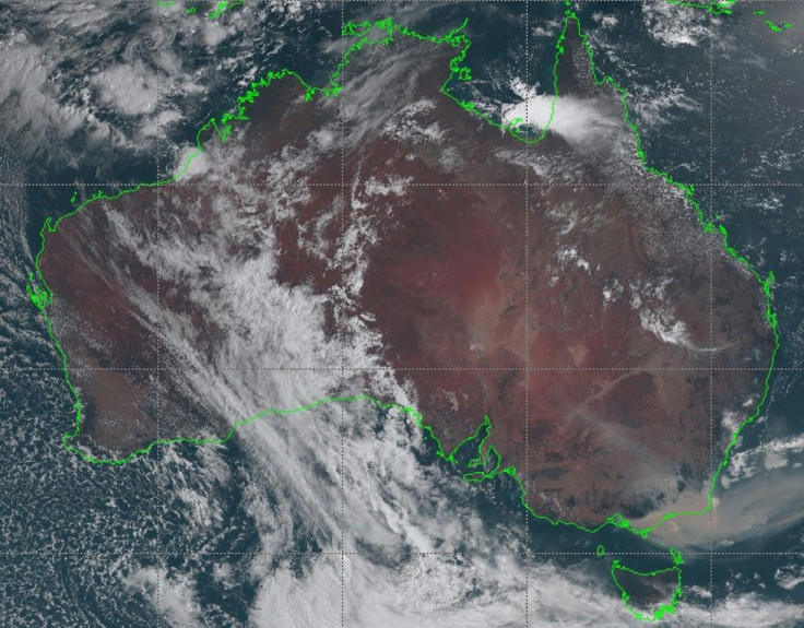
Images taken by satellites hovering thousands of miles above Earth show the destruction of the raging bushfires in Australia. One of the images clearly shows just how big the cloud of smoke the bushfires have generated.
Last week, the Himawari-8 satellite of the Japan Meteorological Agency took photos of Earth from an orbital altitude of about 22,300 miles. Through various sensors and imaging systems, the satellite was able to take various photos showing the effects of Australia’s bushfires, Business Insider reported.
In one of the photos of Earth, plumes of smoke half as big as Europe can be seen. Due to winds, these massive clouds of smoke have started drifting away from Australia and into the skies of neighboring regions such as New Zealand.
In a previous photo taken by Himawari-8 in November, the satellite tracks the fiery hotspots as they spread across different parts of Australia during the start of the bushfires.
Aside from the Japan Meteorological Agency, Europe’s Copernicus Emergency Management Service also released photos of Australia taken from space. The images were captured using the European Space Agency’s Sentinel 2 satellite.
As many of us in the #EU are getting ready to celebrate #NYE2020, our thoughts are with all those affected by disasters, with refugees, with firefighters, emergency managers, paramedics etc. that are on duty in 🇦🇺 & all over#Sentinel2🇪🇺🛰 image of the Bateman Bay #NSW area 31/12 pic.twitter.com/L9Do8wKRPc
— Copernicus EMS (@CopernicusEMS) December 31, 2019
The photo features a large portion of New South Wales being consumed by the ongoing bushfires. It also highlights just how thick the clouds of smoke have become.
Currently, the bushfires in Australia have already burned down 14 million acres of land. Reports indicated that half a billion animals have already died due to the natural disaster. According to 9News, nearly 1,600 homes have already been destroyed across New South Wales and the Australian Capital Territory.
Despite the ongoing efforts of firefighters, military personnel, government agencies and ordinary citizens, experts are not expecting the disaster to end soon. Aside from the fact that Australia is currently going through the summer season, which extends from December to February, the country is also facing one of the harshest droughts in years.
“Warmer than average and drier than average is the trend that looks to be continuing,” meteorologist Tom Hough said according to Daily Mail. “Based off the climate outlooks it doesn't look like we're going to see any significant rainfall.”
© Copyright IBTimes 2026. All rights reserved.
- MOST POPULAR IN Science


