

Tropical Storm Nicole: Satellite Image Shows Cyclone Headed For Florida

KEY POINTS
- The satellite images show how massive Tropical Storm Nicole is
- It made landfall in the Bahamas Wednesday
- It's expected to affect "much of the Florida peninsula"
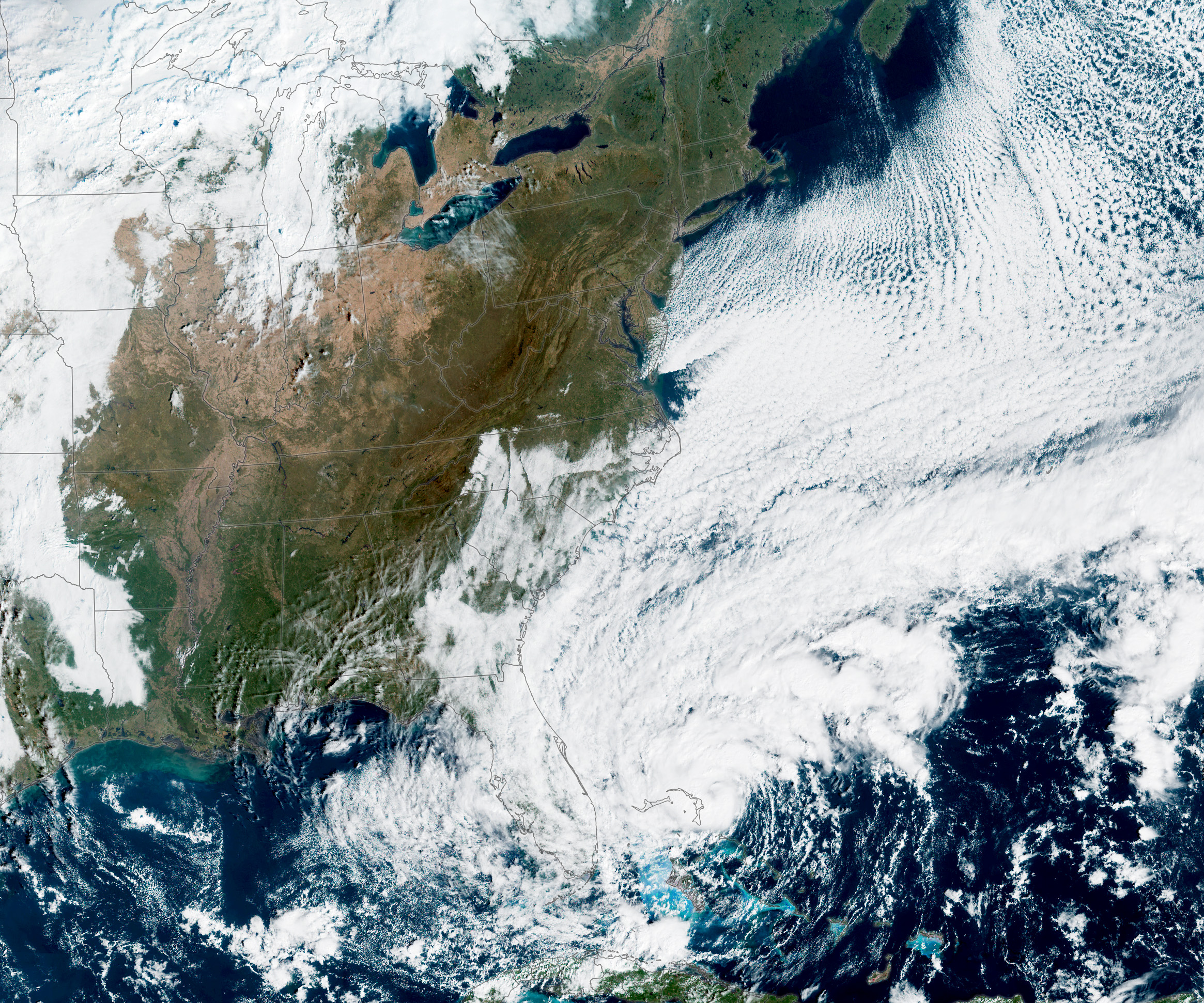
A satellite captured Tropical storm Nicole as it made its way toward Florida. Its size shows that its effects could be "far-reaching."
The image was taken by the Visible Infrared Imaging Radiometer Suite (VIIRS) instrument on the Suomi NPP Satellite at 1 p.m. EST Tuesday, according to NASA Earth Observatory, which shared the photo as its image of the day for Thursday.
In the image, one can see Tropical Storm Nicole with sustained winds of about 60 miles per hour. The agency said the storm's "strongest winds" have been expected to affect parts of Florida's east coast. But given its massive size, which is evident in the photo, it's quite possible that its effects could extend beyond its path.
Tropical Storm #Nicole is approaching #Florida. Forecasters expect the storm to intensify to hurricane strength before reaching southeast or east-central Florida later tonight.https://t.co/0fQ3X4rc9P pic.twitter.com/SyUTlLWXkX
— NASA Earth (@NASAEarth) November 10, 2022
"Dangerous storm surge was expected along coastal Florida and Georgia, while heavy rainfall was expected across much of the Florida Peninsula — bringing even more water to places still recovering from flooding caused by Hurricane Ian in late September," NASA Earth Observatory noted.
Hurricane Ian also caused millions of people to lose electricity at the time of its onslaught.
NASA Earth Observatory shared another satellite image of Tropical Storm Nicole, this time taken by the Advanced Baseline Imager on the GOES-16 satellite at 10 a.m. EST Wednesday. By then, Nicole was already 210 miles off of West Palm Beach, Florida, with sustained wind speeds of 70 miles per hour.
According to the National Hurricane Center's update on the storm at 11 p.m. EST Wednesday, Nicole was already moving away from Grand Bahama Island and was heading toward Florida's east coast.
Here is the 11 PM EST Wed, Nov 9 Hurricane #Nicole hourly update. These updates will continue as long as the center is easily trackable by land-based radar. https://t.co/tW4KeGe9uJ pic.twitter.com/71KH09vhry
— National Hurricane Center (@NHC_Atlantic) November 10, 2022
The "late season" cyclone made landfall in the Bahamas Wednesday morning, CNN reported. It has also strengthened to a Category 1 hurricane with 75 miles per hour winds as it moves toward Florida.
Nicole is expected to bring "strong winds, a dangerous storm surge and heavy rains," as per the National Hurricane Center. People are advised not to focus on Nicole's path, as it is expected to affect "much of the Florida peninsula and portions of southeast United States."
Here are the 10 PM EST Wed, Nov 9 Hurricane #Nicole Key Messages. Nicole is bringing strong winds, a dangerous storm surge, and heavy rains as it approaches the east coast of Florida. https://t.co/tW4KeGe9uJ pic.twitter.com/96mfjQXSPt
— National Hurricane Center (@NHC_Atlantic) November 10, 2022
The agency has also listed the areas where tropical storm, storm surge and hurricane warnings and watches are in effect. It's worth noting that there are differences between a "warning" and a "watch."
Do you know the difference between a Storm Surge Watch and Warning?
— National Weather Service (@NWS) November 10, 2022
A Storm Surge WATCH means storm surge is POSSIBLE within 48 hours.
A Storm Surge WARNING means storm surge is EXPECTED. pic.twitter.com/g7CECZviGJ
"For storm information specific to your area in the United States, including possible inland watches and warnings, please monitor products issued by your local National Weather Service forecast office," the National Hurricane Center noted.
Nicole is expected to "weaken and turn northward" after it makes landfall in Florida, according to NASA Earth Observatory.

© Copyright IBTimes 2025. All rights reserved.
- MOST POPULAR IN Science


