

Apple Maps Fails Again: Alaska Drivers Directed Onto Airport Taxiway, No Fix In Sight

Alaska’s Fairbanks International Airport has closed one of its main access routes for aircrafts due to a major flaw with the Apple Maps navigation application, which is available for iOS 6 and iOS 7 users.
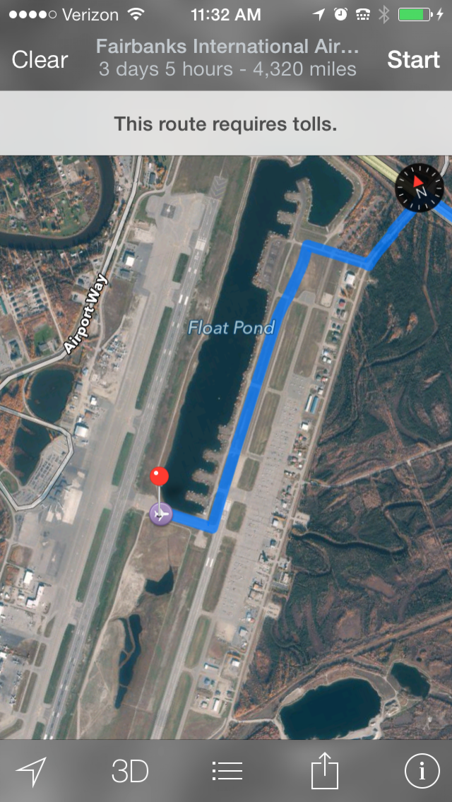
Alaska drivers attempting to get turn-by-turn directions to Fairbanks International Airport with Apple Maps are directed to Taxiway Bravo. By driving across one of the runways, it’s straight to the main terminal. According to the Alaska Dispatch, several drivers have been spotted driving along the taxiway and crossing the runway to reach the airport ramp side of the passenger terminal.
Although Apple Maps does not direct drivers to cross the runway, which is regularly used by 737s and other aircrafts, the turn-by-turn directions specifically tell users to follow the access route, which is only used by aviation pilots.
“These folks drove past several signs,” Melissa Osborn, chief of operations at the Fairbanks airport, told the Alaska Dispatch. “They even drove past a gate. None of that cued them that they did something inappropriate.”
On Sept. 6, a team of police, airport personnel and TSA staffers stopped the driver of a rental car as it was crossing the runway. The airport sent a complaint through the attorney general’s office to Apple, but while Apple’s legal department said the problem would be fixed promptly, Fairbanks International Airport Marketing Director Angie Spear says the dangerous Apple Maps error is still uncorrected.
“No matter what the signs say, the map on their iPhone told them to proceed this way,” Spear said.
Osborn said the airport asked Apple to disable the map for Fairbanks until it could be corrected.
“It would be better to have nothing show up than to take the chance that one more person would do this,” she said.
But sure enough, on Sept. 20, another driver was spotted on the aircraft access route. Since Friday, the route from Float Pond Road to Taxiway Bravo has been effectively closed with barricades, and a Notice to Airmen was issued.
What’s Wrong With Apple Maps?
Osborn believes the main issue lies with how Apple Maps uses the center of the Fairbanks Airport property as the target, rather than the building’s physical address. In fact, the problem does not occur when users manually type the airport’s address, but not many people will type when they can simply point on a map to start the journey.
Apple will fix the Fairbanks issue due to the sheer amount of press from this particular news story, but Apple Maps has a long way to go until it can become as reliable as Google Maps.
Since its debut in September 2012, Apple Maps has been wildly inaccurate at times, even to the point of endangering national security. However, many of these issues will hopefully be fixed by next year, as Apple recently purchased three companies in a two-month span. On July 19, Apple acquired two mapping companies -- Toronto-based Locationary, focused on crowdsourcing location data for local businesses, and New York City-based HopStop, which aggregates massive amounts of data from several hundred transit agencies to help mobile users get from Point A to Point B via subway, bus, train, taxi, walking or biking. On Aug. 23, Apple acquired Embark Inc., which has 10 iOS apps in the App Store to help navigate major cities’ public transportation routes. And even prior to the acquisition spree, Apple in March spent $20 million on another Silicon Valley startup, WiFiSLAM, which allows users to detect and navigate locations with pinpoint accuracy, including "step-by-step indoor navigation to product-level retail customer engagement to proximity-based social networking." With any luck, many of these Maps errors will be minimized or totally eradicated by the time we see iOS 8.
We’ve reached out to Apple for comment, and we’ll update this story as soon as we learn more from the company.
© Copyright IBTimes 2025. All rights reserved.
- MOST POPULAR IN Technology


