

Almost 23% Of Gulf Of Mexico's Oil-And-Gas Output Cut By Storm

Because of Tropical Storm Debby in the Gulf of Mexico, about 22.7 percent of the gulf's current daily oil production and about 22.9 percent of its current daily natural-gas production has been shut-in, according to estimates of the U.S. Interior Department's Bureau of Safety and Environmental Enforcement, or BSEE.
This represents about 313,775 barrels of oil per day and about 1,031 million cubic feet of natural gas per day.
Oil-and-gas operators in the Gulf of Mexico have evacuated at least 61 production platforms -- equivalent to 10.2 percent of the 596 manned platforms there -- the BSEE reported.
The O&G operators also have evacuated at least 13 drilling rigs -- equivalent to 18.6 percent of the 70 rigs operating at present in the Gulf of Mexico -- the BSEE said.
The BSEE figures are based on numbers submitted to it by the O&G operators as of Sunday at 11:30 a.m. CDT (12:30 p.m. EDT).
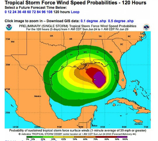
Meanwhile, Tropical Storm Debby's heavy squalls continue to pummel the Gulf Coast of northern and central Florida, according to the U.S. National Hurricane Center, which logged the maximum sustained winds at 60 mph as of Sunday at 7 p.m. CDT (8 p.m. EDT).
A tropical-storm warning is in effect for the Mississippi-Alabama border eastward to the Suwannee River in Florida, and a tropical-storm watch is in effect for the Suwannee River in Florida southward to Englewood, Fla., the NHC reported.
Sustained tropical-storm-force winds have been reported at several locations along the Florida Panhandle west of Apalachicola during the past hour. Wind gusts to tropical storm force have been reported along the Alabama coast and also along the west-central Florida coast, the NHC said.
With the center of Tropical Storm Debby continuing to move slowly, the NHC has raised its estimates of the related storm surge during the past 24 hours. The center now anticipates it could range between one and six feet, depending on location. Surge-related flooding depends on the relative timing of the surge and the tidal cycle, noted the NHC, which also pointed out there can be comparatively large variations over relatively short distances.
Again depending on location, the NHC forecast rain accumulations ranging from 5 to 15 inches are probable, and isolated maximum amounts of 25 inches are possible. Given the recent heavy rainfall and wet soil conditions, the NHC predicted, these additional amounts will exacerbate the flash-flood threat across portions of the central and eastern Gulf Coast.
Tornadoes are also possibilities in Florida on Sunday night, according to the NHC.
© Copyright IBTimes 2024. All rights reserved.
- MOST POPULAR IN Business


