

Hurricane Irene 2011: Category 3 Storm Puts U.S. East Coast on Alert
Virtually the entire U.S. East Coast is on alert late Wednesday for a possible impact from Hurricane Irene, threatening to blaze a trail from eastern North Carolina northward to New England by Monday.
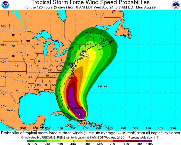
By the time the storm departs the East Coast late Monday, it will likely have lashed with significant impacts from the Bahamas, where it is currently located, to eastern North Carolina, and up through the northeast U.S. -- possibly making a direct hit on Long Island, New York late Sunday.
Irene is the first hurricane of the 2011 Atlantic season and threatening to be the first to strike the U.S. since Ike in 2008.
It looks like Long Island will be impacted in some way by this system, whether it's a hurricane or not when it gets here, said meteorologist Brian Ciemnecki at the National Weather Service in Upton, N.Y. in Newsday. We're definitely going to see some rain and some winds on the ocean, even if it passes nearby.
Earlier on Wednesday, some tourists and residents in the Outer Banks area of North Carolina were being evacuated, as the region faced a high probability of flooding and downed power lines.
Only Florida is likely going to be spared the brunt of the storm. At one point early forecast models showed Irene taking aim at the Sunshine State. But Irene took a northern turn, striking the Bahamas instead. As a result, Palm Beach County public school students who thought they might get a day off from classes on Thursday and Friday will now have to attend.
The National Weather Service indicated that the major threat of effects from Hurricane Irene on South Florida were diminished.
Weather conditions on Thursday and Friday do not appear to pose a safety risk for students, parents, staff and buses traveling to and from school and activities, the Palm Beach County School System said in a statement.
Currently a major Category 3 storm with maximum sustained winds of 120 miles per hour, Irene is moving through the Bahamas, centered 250 miles southeast of Nassau and moving northwest at 12 miles per hour.
Rainfall of six to 15 inches is expected through Thursday night and water levels may rise by five to eight feet in the southeast Bahamas and Turks and Caicos Islands and seven to 11 feet in the central and northwest Bahamas as Irene moves through.
The storm is expected to depart the Bahamas Thursday night, likely running parallel with the Florida and Georgia coasts and passing off the South Carolina coast Saturday, lashing the area with high wind and rain.
But a focus of Hurricane Irene has become forecasts which show Irene possibly making a direct strike on Long Island, with major impact in the New York area and along the highly-populated east coast I-95 corridor. Models currently show Irene could reach the area late Sunday night as a Category 2 storm with winds of 100 miles per hour or higher.
Irene is then expected to bring extreme impacts to region, and on its way up the east coast, with damaging winds, power outages, flooding rains and coastal surge Saturday into Monday.
White House spokesman Josh Earnest said Wednesday that President Barack Obama is confident in FEMA Director William Craig Fugate's abilities to handle an emergency situation should one develop in the coming days with Hurricane Irene. Obama also said that the White House advises residents who live within the path of Hurricane Irene to listen to local emergency officials and follow evacuation and precaution orders if given.
New York Gov. Andrew Cuomo said state and local agencies are meeting Wednesday to prepare response plans for Irene. Cuomo is urging residents to closely monitor the forecast and be prepared to follow instructions of local emergency officials. Cuomo said that parts of the state near coastal waters are at the highest risk, but that inland areas are also subject to flooding and power outages.
© Copyright IBTimes 2025. All rights reserved.
- MOST READ


