

Hurricane Irene Path: Could Become Category 4 by Thursday
Hurricane Irene, which is now lingering in the Bahamas and is expected to hit the U.S. East Coast, is strengthening and could become a Category 4 by Thursday, say forecasters.
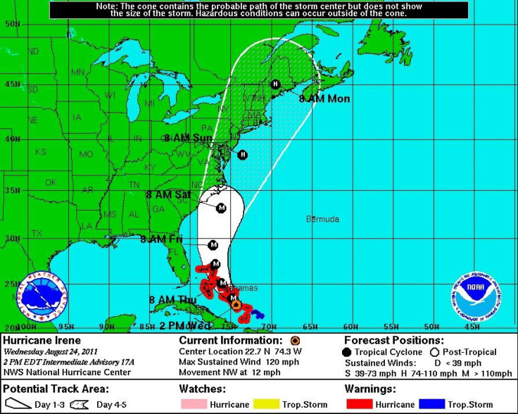
On Wednesday, the National Hurricane Center said Irene was approaching the northwestern Bahamas as a Category 3 storm with winds at 120 mph. Forecasters predict that an additional strengthening is expected during Wednesday night and it could become a Category 4 storm, with winds exceeding 131 mph, Thursday.
Officials have asked tourists and island residents from North Carolina to evacuate by Thursday. Forecasters have warned that Irene could hit North Carolina's coast on Saturday and then threaten the densely populated Northeast, including New York, starting Saturday, an MSNBC report stated.
Beaches in Dare County, N.C., are preparing for evacuations by 8 a.m. on Thursday. Tourists were told to leave Ocracoke Island on Wednesday.
Major cruises had to be canceled due to the major Category 3 storm pounding Bahamian islands with winds, rain and dangerous storm surge late Wednesday.
It's in the warmest water in the most favorable environment for hurricanes so it could get stronger, said Bill Reid, director of the National Hurricane Center, during a briefing on Wednesday.
The exact center of the storm may stay close to the coastline Saturday and then become a threat to Long Island on Sunday, Reid said. Be advised it will be a large circulation as it moves north of the Carolinas so the hurricane force winds, beach erosion, tidal surges will be in play as the storm progresses.
Florida appears lilkely to be spared as Irene track more than 200 miles off its coast. In 1999 Hurricane Floyd, a Category 2 storm, caused major damage in North Carolina and the Northeast.
© Copyright IBTimes 2024. All rights reserved.
- MOST POPULAR IN Society


