

Hurricane Iselle ‘Intensifies’ To Category 4, Closes In On Hawaii

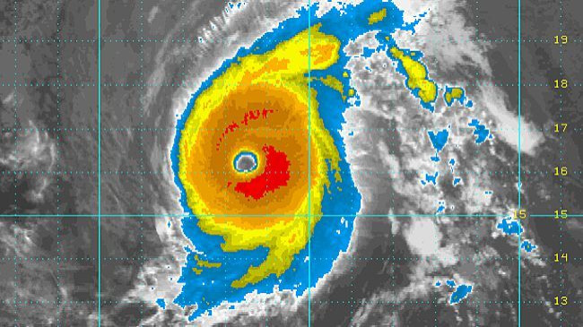
Hurricane Iselle suddenly gained strength over the Pacific Ocean Monday, becoming a Category 4 hurricane with wind gusts reaching 140 mph, U.S. National Hurricane Center said. Meteorologists say the hurricane is headed straight for Hawaii, but is expected to weaken by the time it reaches the islands later this week.
“Iselle continues to intensify and has reached Category 4 strength,” NHC forecasters reported. “Since Iselle has some characteristics of an annular hurricane, it is likely to change little in intensity during the next day or so, and even when it begins to weaken, the trend should be gradual.”
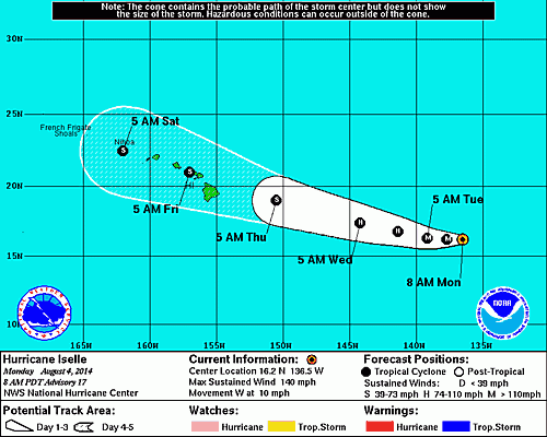
Iselle is currently about 1,250 miles east of Hilo, Hawaii, moving west at 9 mph. The hurricane will reach the Big Island as soon as Thursday. Forecasters say Iselle’s intensity will have diminished by then, becoming a tropical storm, but warn of possible flooding, mudslides and damaging wind gusts near the coasts.
"The 5-day forecast cone brings Iselle at tropical storm strength over or near the Big Island late Thursday night/early Friday morning though likely any affects would be felt on the Big Island beginning Thursday evening," forecasters said. "Long-range models continue to track Iselle toward the west-northwest, which could potentially impact the smaller islands too on Friday.”
On its current trajectory, Hurricane Iselle will pass just north of the Big Island of Hawaii before hitting some of the smaller islands. The approaching storm may cause rough surf and rip currents. Swimmers and boarders are advised to take extreme caution.
Iselle is the ninth named tropical cyclone of the 2014 Pacific hurricane season. The hurricane season runs through the end of November.
© Copyright IBTimes 2025. All rights reserved.
- MOST POPULAR IN Science


