Super Typhoon Neoguri From Space: How NASA Satellites Track Cyclones And Hurricanes

As Japan braces for Super Typhoon Neoguri, NASA has been monitoring the tropical cyclone from space. The International Space Station and NASA’s Earth-observing satellites, Terra and Aqua, have tracked Neoguri as it has developed from tropical storm into a super typhoon.
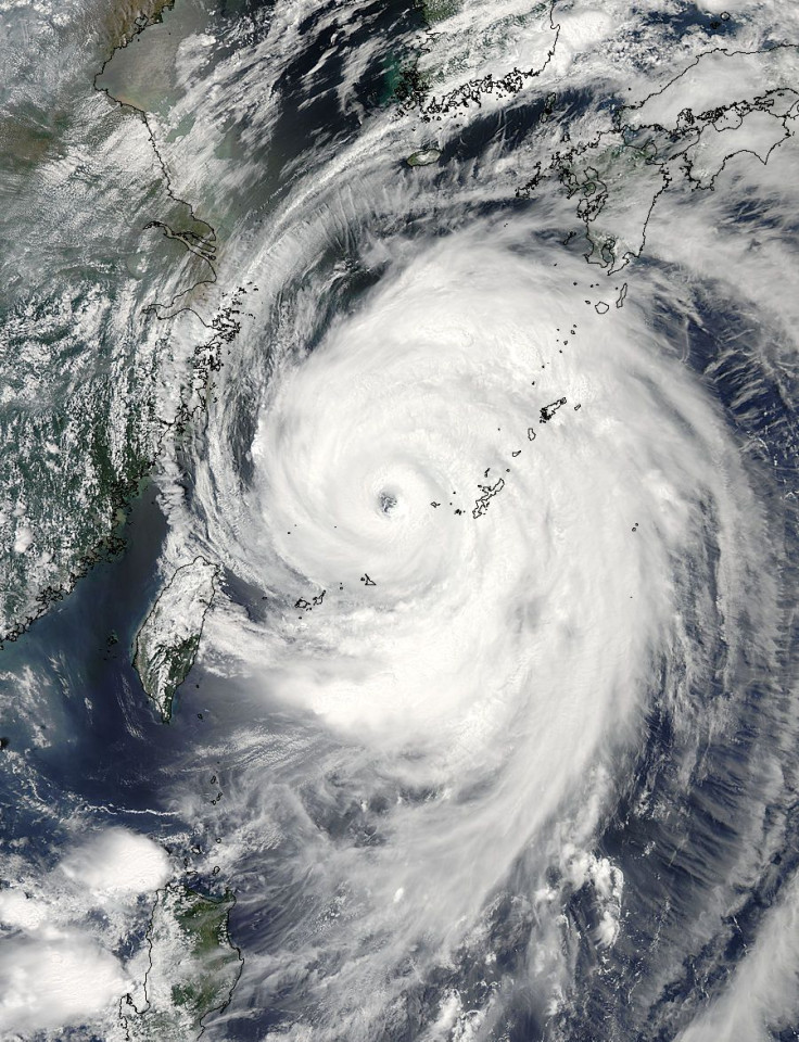
The Terra and Aqua satellites, part of NASA’s Earth Observing System, started tracking Super Typhoon Neoguri when it was 238 miles west of Andersen Air Force Base on Guam, notes the space agency. On Friday, Neoguri had maximum sustained winds around 63 miles per hour and was traveling 14.9 miles per hour northwest. When Neoguri became a typhoon on Saturday, with maximum sustained winds at 132 mph, the Terra satellite captured a photo as it was moving west-northwest at 16 mph.
On Monday, Neoguri was classified as a super typhoon with maximum sustained winds around 150 mph and located 283 miles south-southwest of Kadena Air Base, Okinawa, Japan, reports NASA. Wave heights have increased dramatically due to Neoguri, reaching heights of 40 feet.
Terra, launched in 1999, and Aqua, launched in 2002, are just two satellites in NASA’s EOS fleet. NASA has 22 satellites observing Earth, and their missions range from precipitation measurements to monitoring the North and South Poles.
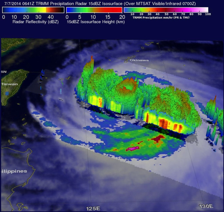
In 2013, NASA, in partnership with Japan Aerospace Exploration Agency (JAXA), launched the Global Precipitation Measurement (GPM) Core Observatory. Most recently, NASA launched the Orbiting Carbon Observatory-2 (OCO-2). The GPM Core Observatory can track rain and snow around the world and can provide updates every three hours once new satellites are launched.
Shortly after the GPM satellite was launched, it provided a 3D look inside a cyclone off the coast of Japan. Last week, the satellite observed Hurricane Arthur off the U.S. East Coast, measuring rainfall and density. According to NASA, the GPM satellite data will be used to refine hurricane intensity predictions.
Jeff Hawkins, head of the Satellite Meteorological Applications Section for the Naval Research Laboratory, said in a statement, “The whole idea here is to use these tools to understand the initial genesis of the tropical cyclone, then to monitor its location, eye structure and intensity as it evolves, and to use that along with our numerical model forecast to generate a five- to seven-day forecast every six hours.” As noted by NASA, GPM data is used by the Joint Typhoon Warning Center in Hawaii and the National Hurricane Center in Miami. The GPM mission builds off of the success of the Tropical Rainfall Measuring Mission, which improved real-time tracking of hurricanes by measuring rainfall.
Went right above Supertyphoon #Neoguri. It is ENORMOUS. Watch out, #Japan! https://t.co/BbwEE2yGIQ pic.twitter.com/IP9clunLF4
— Alexander Gerst (@Astro_Alex) July 8, 2014In addition to satellites, NASA will use the International Space Station to observe Earth. ISS crew members can take images of Earth, such as ESA astronaut Alexander Gerst's pictures of Super Typhoon Neoguri, and the space station will get two more Earth-observing instruments. The ISS-RapidScat will observe wind behavior, which will improve weather and hurricane forecasts, and the Cloud-Aerosol Transport System (CATS) which will bolster climate change observations, reports NASA. All of these tools are part of NASA's Hurricane program.
Other NASA satellites could be used to predict floods. A new study used NASA's Gravity Recovery & Climate Experiment (GRACE) mission data to analyze the 2011 Columbia River flood, and data from GRACE could yield flood predictions three months in advance.
© Copyright IBTimes 2026. All rights reserved.
- MOST POPULAR IN Science