

Hurricane Maria Path: After Puerto Rico, What Area Will Get Hit Next?

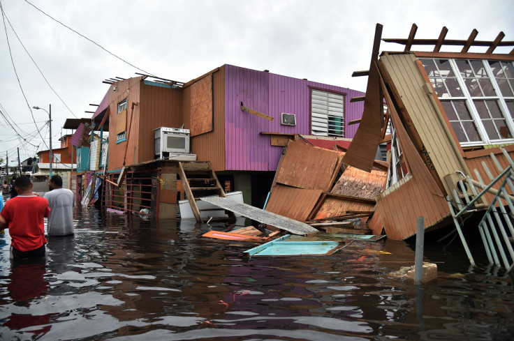
Hurricane Maria devastated Puerto Rico Tuesday as the Category 4 storm was the first of its kind to hit the nation in 85 years. Maria destroyed numerous buildings, caused power outages and brought severe flooding upon arrival and claimed 30 lives. Thousands of people, meanwhile, are in danger due to failure to the Guajataca Dam caused by Maria.
The National Weather Service (NWS) reported that buses are evacuating 70,000 residents from two cities along the Guajataca river for fear of the "extremely dangerous" situation that could occur. Maria has also lashed the Dominican Republic, Punta Cana, Vieques, St. Croix, Turks, Caicos and the Bahamas.
This is an EXTREMELY DANGEROUS SITUATION. Busses are currently evacuating people from the area as quickly as they can #prwx
— NWS San Juan (@NWSSanJuan) September 22, 2017
The path of a hurricane is often difficult to assess, which makes it challenging for weather experts to predict potential targets. Deviations in Hurricane Irma kept the storm from posing a more serious threat in Florida. Maria, however, diminished into a Category 3 storm after departing Puerto Rico Wednesday as it makes it move to potentially lash its next target.
A tropical storm warning had discontinued Saturday for Turks and Caicos as well as the Bahamas. Maria exited the Bahamas on Saturday as a Category 3 storm, but it's expected to pass northeast and east of the Bahamas into Sunday. Gusty winds are still possible in these territories, whereas water levels are expected to subside, according to the National Hurricane Center (NHC). Additional rainfall is expected to come by way of Maria, but the maximum amount predicted in the affected areas would near 2 inches.
The NHC last reported that Maria was about 90 miles north of the archipelago, and roughly 420 miles east-southeast of Nassau. Maria has sustained maximum winds near 120 mph with much higher gusts. Fluctuations in the storm's strength, however, are expected to occur over the next couple of days.
Maria isn't expected to impact the United States severely, but it isn't out of the clear. Maria is said to slide into the Atlantic as it passes between the U.S. East Coast and Bermuda, which would occur by the middle of next week. It's expected to remain out at sea. Direct targets, if any, have yet to be determined at this time.
Maria, as it moves north and northwest, could closely approach the Mid-Atlantic coast, AccuWeather reported Saturday. Maria could target the Outer Banks in North Carolina by Wednesday if the storm moves towards the Mid-Atlantic region.
The storm's long-term path is unclear, but wave action is still likely to occur. Such wave action would include rough surf, dangerous wind currents and heavy seas.
Maria isn't the only storm on the horizon. Tropical Storm Lee strengthened Saturday while drifting slightly northward over the central Atlantic. There aren't any coastal watches or warnings in effect for the "small tropical cyclone" at this time.
"Maximum sustained winds are near 45 mph (75 km/h) with higher gusts," the NHC wrote in public advisory report Saturday. "Some strengthening is forecast during the next 48 hours, and Lee could be near hurricane strength by the end of the weekend."
© Copyright IBTimes 2024. All rights reserved.
-

Bitcoin And Crypto Price Review - Another Myth Gets Busted?
-

Mass Cancellations Loom Despite French Air Union Cancelling Strike
-

Mired In Crisis, Boeing Reports Another Loss
-

Recycled 'Zombie' Misinformation Targets US Voters
-

Hackers Leak Part Of Source Code Of El Salvador's Bitcoin Wallet
-

Azerbaijan Says 'Closer Than Ever' To Armenia Peace Deal Amid Border Talks
-

How UK's Biggest Water Supplier Sank Into Crisis
-

Taiwan Hit By Dozens Of Strong Aftershocks From Deadly Quake
-

Gaza Health System 'Completely Obliterated': UN Expert
-

In Ecuadoran Amazon, Butterflies Provide A Gauge Of Climate Change


