

Hurricane Sandy Predicted To Resemble 1991 'Perfect Storm'
Could Hurricane Sandy spawn a perfect storm?
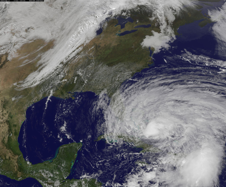
At 11 a.m. Eastern time on Friday, Sandy, which is currently a Category 1 hurricane, was passing over the Abaco Islands in the northern Bahamas. At least 15 people have died in the storm thus far, with 11 casualties in Cuba. And if meterologists’ predictions are correct, Sandy is just warming up -- long after most believed that hurricane season was behind us.
“This is a beyond-strange situation,” Weather Channel hurricane specialist Bryan Norcross wrote in a blog post at Weather Underground on Friday. “It's unprecedented and bizarre.”
Hurricanes usually head out to sea this time of year – it’s pretty much unheard of for an October tropical system to head left and slam into the Northeastern coast, according to Norcross. But that’s what might happen.
Most reliable computer forecast models are predicting that Sandy’s impact will be historic. The hurricane is in the right spot to be sucked back inland by a storm system called a midlatitude trough, which is rolling in from the west. (While Sandy’s companion storm is still unnamed, perhaps ‘Danny’ is appropriate?)
“The double-freak part is that the upper level wind, instead of weakening the storm and simply absorbing the moisture - which would be annoying enough - is merging with the tropical system to create a monstrous hybrid vortex,” Norcross says. “A combination of a hurricane and a nor'easter.”
Kevin Trenberth of the National Center for Atmospheric Research says that climate change may be providing an extra kick to Sandy.
"Sea temperatures are quite high and that means potential for much heavier rains," Trenberth said in a phone interview.
He estimates that the climate change contribution to rains could be as much as a 10 percent effect.
"Instead of 5 inches of rain, you might get 5 and a half," Trenberth said. And that extra half-inch might mean the difference between safely containing storm surges and significant damages.
Some meteorologists are drawing comparisons between Hurrican Sandy and the “Perfect Storm” of 1991, when Hurricane Grace was absorbed by a nor’easter and then wreaked havoc across the eastern seaboard. The Perfect Storm caused about $200 million in damage and killed 13 people. The storm inspired a book about the doomed swordfishing boat, the Andrea Gail, which was later adapted into a movie starring George Clooney.
The conditions for the 1991 storm were somewhat unusual. The nor'easter that mated with Hurricane Grace followed an unusual retrograde path from east of Nova Scotia back towards the U.S. An elongated region of high atmospheric pressure extending from the Appalachian mountains up into Canada forced the low pressure storm system back towards New England.
At the moment, some models are predicting that the storm center will land somewhere between Delaware and New Jersey, which means the Tri-State area is likely in for some fierce weather early next week. Other simulations suggest a landfall somewhere on the mid-Atlantic, which would still cause effects in the Northeast.
A full moon on Monday also means higher tides, so people on the coast should take extra care to watch for evacuation warnings.
National Oceanic and Atmospheric Administration meteorologist Paul Kocin told the New York Times on Thursday that if Sandy, or whatever “Frankenstorm” results from her combination with another system, makes landfall in New Jersey, that would potentially be a ‘worst-case scenario’ for New York City, with intense coastal flooding and winds.
“The storm, wherever it comes in, is going to have a large impact over a lot of people, no matter what,” Kocin said.
To keep up with the latest updates, check out the National Weather Service or the National Hurricane Center.
© Copyright IBTimes 2024. All rights reserved.
-

Bitcoin And Crypto Price Review - Another Myth Gets Busted?
-

Mass Cancellations Loom Despite French Air Union Cancelling Strike
-

Mired In Crisis, Boeing Reports Another Loss
-

Recycled 'Zombie' Misinformation Targets US Voters
-

Hackers Leak Part Of Source Code Of El Salvador's Bitcoin Wallet
-

Azerbaijan Says 'Closer Than Ever' To Armenia Peace Deal Amid Border Talks
-

How UK's Biggest Water Supplier Sank Into Crisis
-

Taiwan Hit By Dozens Of Strong Aftershocks From Deadly Quake
-

Gaza Health System 'Completely Obliterated': UN Expert
-

In Ecuadoran Amazon, Butterflies Provide A Gauge Of Climate Change


