

Investigating Fish Traps From Space: Google Earth Images Reveal Severe Overfishing In Persian Gulf

Google Earth has helped a team of scientists at the University of British Columbia, or UBC, to reveal that large fish traps in Persian Gulf nations could be catching up to six times more fish than they officially reported.
During 2005, there were 1,900 fishing weirs, or small dams built to catch fish, along the Persian Gulf coast, that caught 31,433 tons of fish that year, the UBC researchers estimated, based on satellite imagery from Google Earth. The six countries in the region, however, had reported to the United Nation’s Food and Agriculture Organization that only 5,260 tons of fish were caught during the period.
“Underreporting fish catches can jeopardize a country’s food security, economy, not to mention impact entire marine ecosystems,” Dalal Al-Abdulrazzak, of the UBC Fisheries Centre’s Sea Around Us Project and the study’s lead author, told Quartz, an online publication. “This is particularly important in the case of the Persian Gulf, where fisheries are the second most important natural resource after oil.”
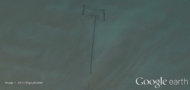
According to the study published Monday in the ICES Journal of Marine Science, fishing weirs are semi-permanent traps that are used to catch marine life with the help of tidal differences. Used in Southeast Asia, Africa and parts of North America, some fishing weirs can be more than 100 meters long.
“This ancient fishing technique has been around for thousands of years,” Al-Abdulrazzak said in a statement. “But we haven’t been able to truly grasp their impact on our marine resources until now, with the help of modern technology.”

The scientists first measured the size of each fish weir’s traps by using a Google ruler tool, and then calculated daily fish catch based on historical records, the length of the fishing season, and the composition of fish species, such as mackerel, crab, lobster and sardines, at each location, Quartz reported.
The study revealed that a majority of the weirs were found in Bahrain (50 percent), followed by Iran (37 percent) and Kuwait (5 percent), while Bahrain also led in terms of estimated catch (54 percent), followed by Iran (39 percent). Estimated catches for Bahrain were 142 percent greater than total catches reported to the FAO.
“Time and again we’ve seen that global fisheries catch data don’t add up,” Daniel Pauly, principal investigator with the Sea Around Us Project and the study’s co-author, said. “Because countries don’t provide reliable information on their fisheries’ catches, we need to expand our thinking and look at other sources of information and new technologies to tell us about what’s happening in our oceans.”
© Copyright IBTimes 2025. All rights reserved.
- MOST POPULAR IN Technology


