

NASA Releases First Complete Map of Antarctic Ice Flow

NASA recently released the first complete map charting the movement of ice sheets in Antarctica.
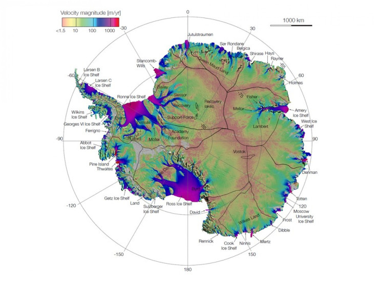
The map, which will be beneficial for tracking future sea-level increase from climate change, provides the speed and direction of ice flow in Antarctica. It shows glaciers flowing thousands of miles from the continent's deep interior to its coast, NASA said.
It was created by NASA-funded researchers, who ? with the help of NASA technology - pieced together the shape and velocity of glacial formations. That includes the previously uncharted East Antarctica, which makes up 77 percent of the continent.
After its completion, the scientist discovered a new ridge splitting the 5.4 million-square-mile (14 million-square-kilometer) landmass from east to west. The team also realized there was an unnamed formations moving up to 800 feet (244 meters) annually across immense plains sloping toward the Antarctic Ocean and in a different manner than past models of ice migration, NASA said.
The map points out something fundamentally new: that ice moves by slipping along the ground it rests on, said Thomas Wagner, NASA's cryospheric program scientist in Washington, in a statement. That's critical knowledge for predicting future sea level rise. It means that if we lose ice at the coasts from the warming ocean, we open the tap to massive amounts of ice in the interior.
Eric Rignot of NASA's Jet Propulsion Laboratory in Pasadena, Calif., called the map a game changer.
This is like seeing a map of all the oceans' currents for the first time, Rignot said in a statement. It's a game changer for glaciology.
Rignot is lead author of a paper on the ice flow published online Thursday in Science Express.
We are seeing amazing flows from the heart of the continent that had never been described before, he added.
Learn more from this video below.
© Copyright IBTimes 2025. All rights reserved.
- MOST POPULAR IN Society


