

New Orleans, Gulf Coast Warned: Gulf Storm Posing Major Threat Labor Day Weekend
Louisiana has declared a state of emergency, and Alabama, Florida, Mississippi are warned to be on alert as the tropical depression that's likely to become Tropical Storm Lee or Hurricane Lee poses a significant threat to the U.S. Gulf Coast region through the extended Labor Day weekend.
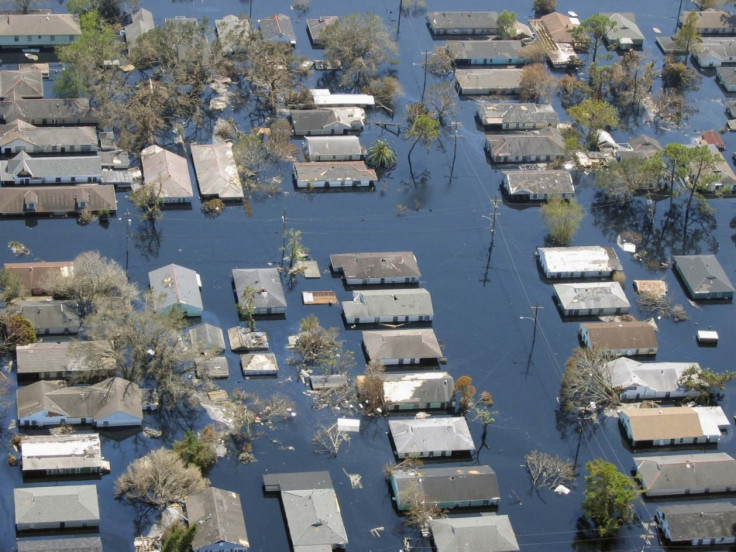
Heavy rains and flooding are forecast as the storm moves ashore sometime before Monday, forecasters say. The storm packs significant risk because it is slow-moving and the potential exists for major flooding in New Orleans, the city decimated during Hurricane Katrina in 2005.
This could be a very heavy, prolific rainmaker, National Weather Service meteorologist Frank Revitte told MSNBC.
Concerns in New Orleans are rising. With some models indicating the city could get 15 to 20 inches of rain or more, that's in excess of total rainfall from Hurricane Katrina which breached levees after 15 inches of rain. That was combined with significant storm surge with raised water levels in Lake Pontchartrain, but 20 inches could push water to dangerous levels again if Lee emerges as near a Category 1 hurricane.
What's more, the Times Picayune reported Friday that a forthcoming Army Corps of Engineers report will give the city's levee system a near-failing grade despite a $10-billion post-Katrina rebuilding job.
The wind threat from the storm is low compared to major hurricanes -- but it also could increase as the storm intensifies, forecasters say. Officials are urging residents with plans along the Gulf Coast this weekend to closely monitor the storm's track and development. Already, some oil companies have ordered evacuations of personnel off offshore rigs as the storm intensifies.
Current models show Tropical Depression 13 would make landfall in southern Louisiana Monday morning as a tropical storm, packing winds of 60 miles per hour. But the forecast also shows the storm would be near the Louisiana coast on Saturday evening, meaning days of torrential rains -- possibly exceeding 20 inches -- will pound the region.
The tropical depression is likely to become Tropical Storm Lee, the 12th named storm of the Atlantic hurricane season. Last week, Irene became the first hurricane to strike the U.S. since Hurricane Ike in 2008.
Tropical storm warnings have been posted from Mississippi to Texas, including New Orleans, where current forecast models show the biggest threat and potential impact. The National Hurricane Center said the system will pour massive amounts of rain over southern areas of the coast.
Already Friday, New Orleans is being lashed with heavy rains. The forecast calls for a 70 percent chance of precipitation Friday and Saturday, with easterly winds gusting from 20 to 35 miles per hour.
Tropical Depression 13, which the storm is currently being called, has a slow northwest movement forecast through Friday, followed by an expected turn toward the north on Friday night and Saturday. The center of the cyclone is expected to approach south Louisiana during the weekend. Gradual strengthening is forecast, and the depression could become a tropical storm on Friday.
Forecasters say isolated amounts of rainfall of 20 inches are possible, with widespread accumulations of 10 to 15 inches. Also, storm surge water levels could rise by as much as 2 to 4 feet above ground level of onshore flow.
© Copyright IBTimes 2025. All rights reserved.
- MOST READ


