Roanoke Colony Mystery Solved? ‘La Virginea Pars’ Map Holds New Clues On Disappearance Of Lost Colonists [PHOTOS]

A mystery surrounding a 16th century North Carolina colony may be one step closer to being solved.
Settlers belonging to what is now known as "Roanoke’s Lost Colony" disappeared centuries ago, showing no signs of conflict or struggle. The only clues were the words "Croatoan" and "Cro" carved into a fort's gatepost and a nearby tree, Fox News reports.
The lost colony belonged to a third group of English settlers arriving in North Carolina’s Roanoke Island. The first group arrived in 1584, the second in 1585, driven out a year later by local Native American Tribes. The third group arrived in 1587, consisting of 17 women and 11 children accompanied by 90 men. But when a separate group of colonists reached the settlement in 1590, they were nowhere to be found – except for the words "Croatoan" and “Cro” engraved onto a wooden post and tree, respectively.
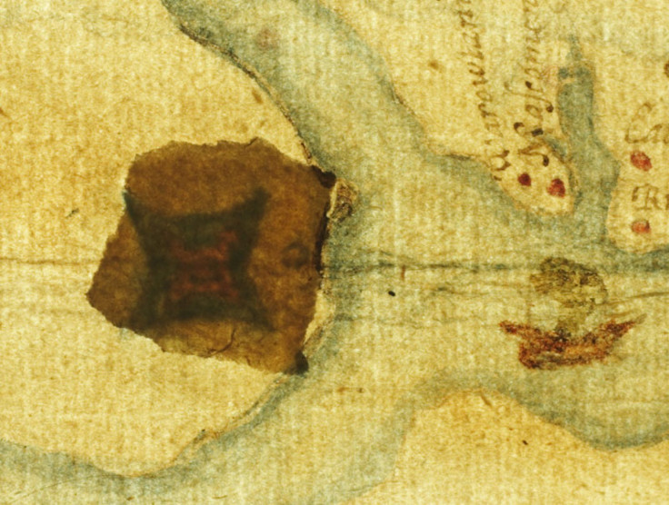
While conspiracy theories surfaced pointing to possible explanations, recently researchers have started reinvestigating the case and found a clue on an old forgotten map of the area named “La Virginea Pars.” The map, which was drawn by the colony’s governor John White, was examined at the British Museum, where researchers found a small red-and-blue symbol believed to be a marker for a secret fort that the settlers escaped to, the Guardian Express reports.
Researchers theorize that the colony would split up into smaller groups when in danger – a strategy the colony used in the past.
"It's obvious that that's the only way they could have survived. No single Indian tribe or village could have supported them ... They were over a hundred people," historian and principal investigator Eric Klingelhofer of Mercer University in Macon, Ga., told National Geographic.

Researchers have yet to determine where the colonists went to, if they indeed fled. One theory points to a location 50 miles south in an area then known as Croatoan Island. Others say the colonists could have fled west via Albemarle Sound to the mouth of the Chowan River and sought shelter with a sympathetic tribe.
"It's a very strategic place, right at the end of Albemarle Sound," he said. "You can go north up the Chowan River to Virginia or west to the Blue Ridge Mountains. They were big trading partners" with other Native American tribes.
Armed with this new information, researchers set out to the location on the map to dig for answers. Using magnetometers and ground-penetrating radar (GPR), researchers were able to find the area on the map, then used GPR to send radio waves underground, looking for buried objects. Iron cannons, graves and coffins were detected. Researchers also found a previously undetected pattern that may belong to a wooden structure.
"I don't know if it's one or a group [of structures]," Malcolm LeCompte, a research associate at Elizabeth City State University in North Carolina, said, adding that they "could be joined or they could be close together."
While the buried structures point to a colonial presence in the area, there are still unanswered questions.
"We have to go in and dig some holes, I guess," Clay Swindell of the Museum of the Albemarle in Elizabeth City, N.C., said.
© Copyright IBTimes 2026. All rights reserved.
- MOST POPULAR IN Technology