

Scientists At NASA And NOAA Develop New Technique To Accurately Monitor Ice On The Great Lakes

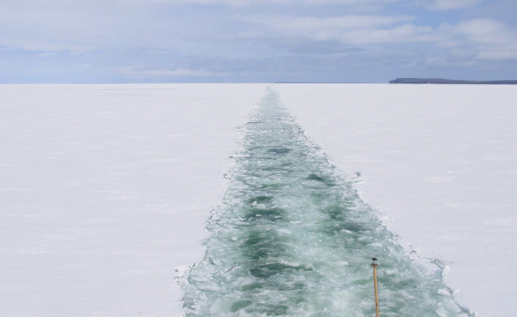
Two scientists from NASA and the National Oceanic and Atmospheric Administration, or NOAA, have developed a technique to monitor ice cover on the Great Lakes, using satellites hundreds of miles up in space. And, the technology is said to be accurate enough to detect an icebreaker cutting open a channel of water through the ice at night.
“In the dark, it’s difficult to read a map that’s right in front of you,” Son Nghiem of NASA and one of the developers of the new technique, said in statement. “Yet we now have a way to use satellite radars almost 500 miles [800 kilometers] out in space to see through clouds and darkness and map ice across the Great Lakes.”
Ice on the Great Lakes is a major concern for regional economies in the U.S. and Canada, which are home to the five lakes that account for more than a fifth of the planet's fresh water. Ice on the lakes affects shipping, fishing and also public safety when winter and spring flooding are caused by ice jams, and has a significant impact on the regional environment and ecosystem.
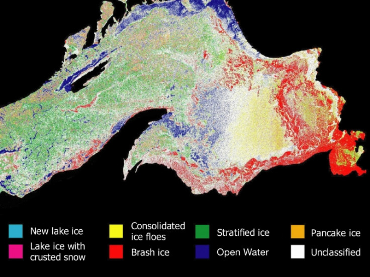
According to the scientists, previous techniques of analyzing satellite observations of the ice cover on the Great Lakes sometimes misidentified ice as water and vice versa. However, the new method, developed by Nghiem with George Leshkevich of NOAA’s Great Lakes Environmental Research Laboratory in Ann Arbor, Mich., is said to have corrected the problem. The technique also precisely identifies ice characteristics, such as whether the ice is dense or full of bubbles, or whether it has melted and refrozen.
According to NASA, the method employs “a special dictionary,” which is capable of translating binary digital data from satellite radar instruments on the Canadian Space Agency’s RADARSAT-1/2, the European Space Agency’s European Remote Sensing Satellite 2 (ERS-2), and Envisat to identify and map different types of ice on the lakes.
The researchers then compare each observed ice type to a library of unique radar signatures, which were measured on the lakes by using an advanced radar developed by NASA, aboard a U.S. Coast Guard icebreaking ship.
“These maps will provide important information for environmental management, ice forecasting and modeling, off-shore wind farm development, operational icebreaking activities in support of winter navigation, and science research,” Leshkevich said, adding that the method has now been used by NOAA for generating ice maps across the Great Lakes.
Scientists believe that the more accurate classification of ice will also help determine how the Great Lakes are responding to, and leading, climate change in the upper Midwest. Results of a study, related to the method, were published recently in the Journal of Great Lakes Research.
More information can be found on the International Association for Great Lakes Research website.
© Copyright IBTimes 2024. All rights reserved.
-

Gaza Health System 'Completely Obliterated': UN Expert
-

In Ecuadoran Amazon, Butterflies Provide A Gauge Of Climate Change
-

50 Years On, Vintage Vehicles To Reenact Portugal's Carnation Revolution
-

Conflicts Push Military Spending To 'All-time High': Report
-

'Thank You, America:' Zelensky And Netanyahu Applaud House Passage Of Foreign Aid Package
-

Women Journalists Bear The Brunt Of Cyberbullying
-
US Aid Shows Ukraine Will Not Be 'Second Afghanistan': Zelensky
-

Elon Musk's X Fights Australian Watchdog Over Church Stabbing Posts
-

Ukraine, Israel, TikTok: The Massive Aid Package Before US Congress
-

Eiffel Tower Loses Sparkle For Parisians Ahead Of Olympics


