

Typhoon Mawar: Satellite Images Show Intensity Of Storm That Battered Guam

KEY POINTS
- Satellite images show Mawar covering Guam
- The storm is moving away from Guam but has re-intensified to a super typhoon
- It is expected to continue intensifying in the coming days
Typhoon Mawar unleashed its power this week as it lashed the U.S. territory of Guam. Satellite images show the sheer intensity of the "strongest storm" to hit the region in years.
Mawar is now moving away from Guam after battering the U.S. territory with intense winds on Wednesday. Although the exact extent of the damages remains to be seen, there have been reports of blackouts, flash floods, fallen trees and cars being flipped over, according to AP News.
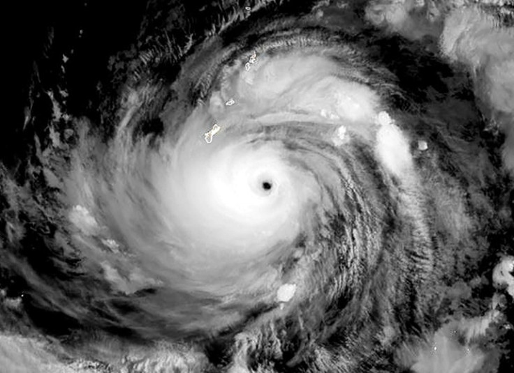
Satellite imagery of Mawar shows just how intense it truly is. For instance, in the image taken by the Visible Infrared Imaging Radiometer Suite (VIIRS) instrument on the NOAA-20 satellite, seen here as shared by the NASA Earth Observatory, one can see just how massive its scope was as it completely covered Guam and the Mariana Islands (the small dots at the center).
Another satellite image from the Suomi NPP satellite also highlights its sheer intensity while it was approaching Guam. In fact, it is the "strongest storm to hit the region in over 60 years," according to the National Oceanic and Atmospheric Administration (NOAA).
Infrared imagery from the @NOAA/NASA #SuomiNPP satellite shows the intensity of Super Typhoon #Mawar as it approached Guam. The storm's eyewall clipped the northern tip of the island early this morning, bringing destructive winds, a life-threatening storm surge, and torrential… pic.twitter.com/2bCpqB8fkT
— NOAA Satellites (@NOAASatellites) May 24, 2023
The Himawari-9 satellite also caught a rather intense view of the storm as it covered the islands entirely.
Here's the sunset view of Typhoon #Mawar nearing #Guam on May 24th via Himawari-9 Visible satellite imagery. https://t.co/NgSJnazWzW pic.twitter.com/j73JDsnBMC
— UW-Madison CIMSS (@UWCIMSS) May 24, 2023
Mawar was initially a super typhoon but was downgraded to a typhoon category as it weakened earlier in the week. However, it strengthened once again as it moved away from Guam, and has now re-intensified into a super typhoon. It is expected to intensify even further in the coming days.
Neighboring country Philippines, which has been keeping an eye on the storm, is continuing to monitor the situation. Given Mawar's current movements, it may enter the country's area of responsibility on Friday evening or Saturday morning, as per the Philippine Atmospheric, Geophysical and Astronomical Services Administration (PAGASA).
"MAWAR is forecast to continue intensifying in the next three days and may reach a peak intensity of 215 km/h by Sunday," the agency noted in an advisory. "Afterwards, the super typhoon is forecast to weaken although it will remain a typhoon by the end of the forecast period."
TROPICAL CYCLONE ADVISORY NO. 2A
— PAGASA-DOST (@dost_pagasa) May 24, 2023
Super Typhoon “MAWAR”
Issued at 5:00 AM, 25 May 2023
Valid for broadcast until the next advisory at 11:00 AM today
“MAWAR” RE-INTENSIFIES INTO A SUPER TYPHOON AS IT MOVES AWAY FROM GUAM IN THE NORTHERN MARIANA ISLANDS pic.twitter.com/AZ2MjDdUSh
People can follow the path of the storm here.
As for Guam, which has been recovering, conditions are expected to improve by Thursday, and authorities are set to assess the full extent of the damages that Mawar left behind. For instance, there have been reports of impassable roads and communication issues due to internet failures, as per AP News.
President Biden already declared an emergency in Guam earlier in the week, thus authorizing the deployment of federal assistance and response efforts in the territory.
"The President's action authorizes the Department of Homeland Security, Federal Emergency Management Agency (FEMA), to coordinate all disaster relief efforts which have the purpose of alleviating the hardship and suffering caused by the emergency on the local population, and to provide appropriate assistance for required emergency measures ...to save lives and to protect property and public health and safety, and to lessen or avert the threat of a catastrophe in the territory of Guam," the declaration noted.
© Copyright IBTimes 2024. All rights reserved.
-

Romney Says Biden Made 'Enormous Error' By Not Pardoning Trump In Hush Money Case
-

Hunter Biden's Imminent Trial Raises White House Concerns
-

Monetary Metals Yield: Ushering In A Golden Era, One Ounce At A Time
-

'Ready To Rumble' - Biden, Trump Agree To Two Election Debates
-

Hong Kong's Financial Empire Faces Critical Turning Point As Chinese Power Increases
-

Top UN Court Hears S. Africa Calls To Stop Israel Rafah Offensive
-

Qatar Eyes More Long-term Gas Supply Deals This Year
-

Barge Collision In Texas Causes Oil Spill, Shuts Down Pelican Island Bridge
-

Pro-Turkey Syria Mercenaries Head To Niger To Earn Cash
-

A Gloomy Season For Ethiopia's 'Green Gold' At The Khat Market


