

U.S. Alert as Hurricane Irene Threatens East Coast
Hurricane Irene posed a potential threat to the entire U.S. East Coast from Florida to New England, U.S. officials said on Tuesday, as forecasters tried to predict where the powerful storm might hit over the next week.
U.S. Federal Emergency Management Agency (FEMA) Administrator Craig Fugate and National Hurricane Center Director Bill Read issued the warning as Irene swept up from the Caribbean on a northwest track toward the United States.
We're going to have a very large tropical cyclone move up the Eastern Seaboard over the next five to seven days, Read told a conference call in which he spoke along with Fugate.
The FEMA chief said residents all along the East Coast should be alert not only to a potential direct landfall but also to the risk of torrential rains, high winds and flooding that Irene could bring.
We're saying the entire East Coast, Fugate said.
Irene, now a Category 2 storm, was heading on Tuesday over the Turks and Caicos Islands and southeastern Bahamas. It was expected to become a major Category 3 storm, with winds over 111 mph, by Wednesday and could possibly intensify further to a Category 4 as it neared the southeast U.S. coast by Friday.
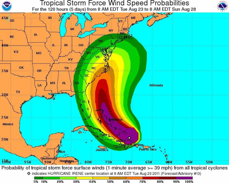
Calling Irene a very large storm, Read said the Miami-based NHC's best guess forecast at the moment was that the hurricane would approach the coast of the Carolinas on Saturday morning as a major storm, of Category 3 or upward on the five-step Saffir-Simpson scale of intensity.
Read said the storm will skirt south Florida but added that after the Carolinas, the New England region of the East Coast could also be at particular risk.
We're going to potentially see tropical storm-force conditions, very hazardous beach conditions, Fugate said, adding evacuations of coastal areas could be needed.
Irene, the first hurricane of the busy 2011 Atlantic season, looks set to be the first hurricane to hit the United States since Ike pounded the Texas coast in 2008.
At 11 a.m. (1500 GMT), Irene had top winds of 100 miles per hour and was 70 miles south of Grand Turk Island in the Turks and Caicos and 50 miles north northwest of Puerto Plata, Dominican Republic.
Hurricane force winds extended outward up to 50 miles from Irene's center and tropical storm force winds extended out up to 205 miles, the NHC said.
© Copyright Thomson Reuters 2024. All rights reserved.
-

Microsoft Expands Its AI Empire Abroad
-

Oil: 'Mother Of Corruption' In Venezuela
-

'Extreme' Climate Blamed For World's Worst Wine Harvest In 62 Years
-

Macron Warns 'Mortal' Europe Needs Credible Defence
-

Bitcoin And Crypto Price Review - Another Myth Gets Busted?
-

Mass Cancellations Loom Despite French Air Union Cancelling Strike
-

Mired In Crisis, Boeing Reports Another Loss
-

Recycled 'Zombie' Misinformation Targets US Voters
-

Hackers Leak Part Of Source Code Of El Salvador's Bitcoin Wallet
-

Azerbaijan Says 'Closer Than Ever' To Armenia Peace Deal Amid Border Talks


