Water On Mars: NASA’s MRO Snaps Image Of Sedimentary Rock Layers In Valles Marineris’ Ganges Chasma

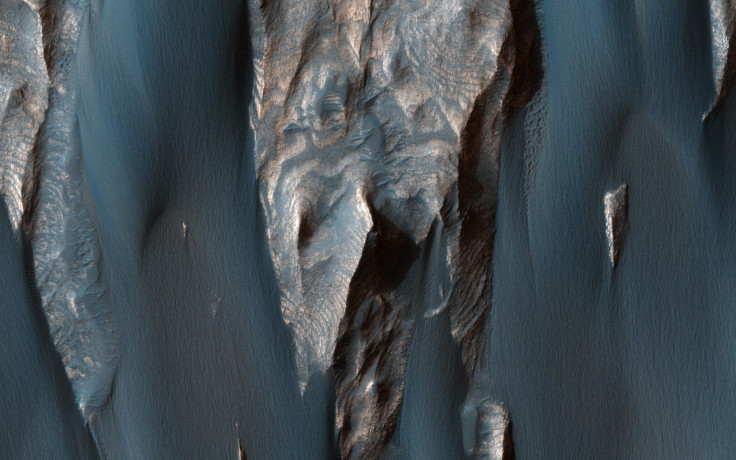
NASA’s Mars Reconnaissance Orbiter has snapped a stunning new image of a canyon in the Valles Marineris system. The photograph, captured using the MRO’s HiRise camera, shows sedimentary rock layers — most likely formed in the presence of water — in the Ganges Chasma region.
“These features are at once familiar and unusual to those familiar with Earth's beaches and deserts,” NASA explained in a statement accompanying the image. “Most sand dunes on Earth are made of silica-rich sand, giving them a light color; these Martian dunes owe their dark color to the iron and magnesium-rich sand found in the region.”
In recent years, observations made using NASA’s Curiosity rover and the MRO have provided ample evidence that water once flowed on the surface of the red planet. Earlier this month, the space agency released an image showing layered deposits of sediments in the Melas Basin — also a segment of the Valles Marineris canyon system.
“The layered deposits in Melas Basin may have been deposited during the growth of a delta complex,” NASA said in a statement at the time. “This depositional sequence likely represents a period where materials were being deposited on the floor of a lake or running river.”
Data previously collected by the MRO and Curiosity has bolstered the theory that roughly 4.3 billion years ago, Mars had enough water to cover its entire surface in a liquid layer about 450 feet deep. Evidence also suggests that long after solar winds stripped the red planet of its atmosphere, turning it into the cold, arid world it is today, lakes of water and snowmelt-fed streams still existed on its surface.
Some studies have even suggested that about 3.8 billion years ago, Mars had enough liquid water to form an ocean occupying almost half of its northern hemisphere.
The MRO has been orbiting the red planet since 2006, and has beamed back striking photos of Mars to Earth every month. Last August, NASA published its largest dump of images captured by the MRO’s HiRise camera, releasing a cache of over 1,000 photos that show the Martian surface in all its glory — from dunes and craters to mountains and ice caps.
All the photos in the image dump were taken in May, when Mars experienced its equinox — a period during a planet’s orbit when the sun shines directly on its equator, lighting up both its poles. Coincidentally, as Alfred McEwen, the director of the Planetary Image Research Laboratory, explained to Popular Science at the time, the equinox overlapped with the period when Mars and the sun were on the opposite sides of Earth — a phenomenon that facilitates unobstructed communication between the MRO and ground control.
As a result, the satellite was able to send a hefty amount of data in a short period of time.
The entire collection of images captured so far by the HiRise camera can be viewed here.
© Copyright IBTimes 2026. All rights reserved.
- MOST POPULAR IN World