

California Faces Tsunami Threat From A 'Complicated Logjam' Of Faults Off West Coast


Despite being criticized for its shaky science, the release of “San Andreas” -- starring Dwayne “The Rock” Johnson as a rescue-chopper pilot trying to save his family -- has triggered a scientific debate over whether the catastrophe shown in the movie could happen in real life. The disaster flick shows a massive earthquake caused by a shift in the San Andreas Fault, which forms the tectonic boundary between the Pacific Plate and the North American Plate.
In a new study, published in the Journal of Geophysical Research: Earth Surface, scientists warn that while the extent of damage shown in the movie is unlikely to happen in real life, there are several long faults with the potential for tsunami-generating earthquakes within 90 miles of the U.S. West Coast.
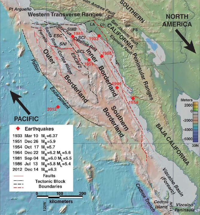
“There are many active faults offshore southern California which could produce greater then magnitude 7 quakes and tsunamis,” Mark Legg, who runs a Southern California consulting firm called Legg Geophysical and is the lead author of the study, told Discovery News. However, he added, unlike the movie, such disasters would probably be caused by the little known California Continental Borderland -- an undersea landscape off the coast of Southern California and northern Baja California.
The surveys of the region show a “complicated logjam” of faults produced by the movement of the Pacific Plate, which is sliding northwest relative to the North American Plate. For the purpose of this study, Legg and his colleagues collected data about seafloor depth to work out the lengths of two of the largest faults in this logjam -- the Santa Cruz-Catalina Ridge Fault and the Ferrelo Fault.
“What they were searching for are signs, like those seen along the San Andreas, that indicate how much the faults have slipped over time and whether some of that slippage caused some of the seafloor to thrust upwards,” the American Geophysical Union, which publishes the journal, said, in a press release.
While analyzing this data, the researchers found that the blocks of crust were being subjected to vertical movements in the region because of a phenomenon known as “transpression,” which happens when faults slip horizontally relative to each other. Such a process, believed to be responsible for the creation of the Transverse Ranges in southern California, has the potential to cause the seafloor to rise and send a tsunami-generating pulse toward the shore.
However, the results of such a process would still not be as dramatic as shown in the movie, Lucy Jones, science adviser for risk reduction in the U.S. Geological Survey's Natural Hazards Mission Area, told NBC News.
“It's not that it's not a risk,” she said. “It's just not as big a risk as the ones we see from the big subduction zones.” Subduction zones are regions where one tectonic plate is being forced under another. Such a zone is not present off the coast of southern California.
But, even if the resulting tsunami generates one- to two-meter surges, it could have a huge impact on ports in the region, Legg warned, calling for a closer study of the undersea faults. “We’ve got high resolution maps of the surface of Mars,” Legg said, in a statement. “Yet we still don’t have decent bathymetry for our own backyard.”
© Copyright IBTimes 2025. All rights reserved.
- MOST POPULAR IN Science


