

Greenland Ice Melt Just Part Of Larger Warming Trend, Experts Say
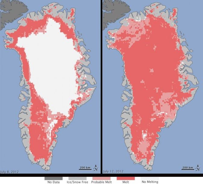
NASA satellites have noticed something alarming: The vast ice sheet that covers much of Greenland melted at its surface across a wider range than scientists have ever seen since they started keeping measurements 30 years ago.
But the Greenland ice melt isn't an isolated incident; Arctic sea ice coverage is on track to match or even break the record low set in 2007. Scientists have long held that the Arctic is the proverbial canary in the coal mine that will alert us to the looming effects of climate change. Right now, this bird doesn't look too good.
University of Georgia climatologist Thomas Mote was one of several independent researchers who used his own methods to confirm what the NASA satellites were seeing -- that around 97% of the ice sheet's surface had thawed by July 12.
I was a bit taken aback, Mote said in a telephone interview.
The 660,000 square mile ice sheet that covers more than three-quarters of Greenland is thin at the edges but nearly 2 miles thick at its thickest point. Every year, about half of its surface melts over the summer, but at high elevations, this meltwater usually refreezes quickly.
Normally, the first big wave of melting occurs across the sheet in mid-June. But this year, the melt started around the end of May. There were also larger areas of melt at high altitudes, and melting at lower elevations was occurring more frequently than normal, according to Mote.
Other signs have pointed to this being a particularly warm year. Last month was either the warmest June on record or the fourth warmest since 1880, depending on whether you look at the global averages for just land temperature or combined land and ocean temperatures. June was also the month that the National Snow and Ice Data Center (NSIDC) saw the least amount of snow coverage across the Northern Hemisphere since 1967.
The Greenland ice sheet melt is just part of the larger picture of extreme warmth over the Arctic, says NSIDC director Mark Serreze.
Sea ice is also melting at a near-record pace this year, according to Serreze.
The NSIDC found that in June, the Arctic sea contained an average of 4.24 million square miles of sea ice, 456,000 million square kilometers below the average June coverage from 1979 to 2000. The Arctic also lost 1.10 million square miles of ice that same month, the largest June ice loss in the satellite record.
Right now the data shows that the Arctic is on track to match the record 2007 sea ice loss, if not surpass it. Scientists won't truly know the extent of the loss until September, at the end of the melting season. That's when scientists will be able to compare the amount of ice lost during the summer to the ice buildup over the winter.
Still, just because the sea ice is tracking toward a record low, that doesn't necessarily mean it'll get there, even if there's abnormally warm weather. Temperature isn't the only factor in ice melt -- weather also plays a role. High pressure systems associated with clear weather are more conducive to ice loss, while stormier weather helps preserve ice, according to Serreze.
What happens in the Arctic is also likely to cause weather effects in other areas, though scientists aren't exactly sure what form these regional effects will take. Weather conditions in the Northern Hemisphere are largely the result of the vast temperature gradient from the warm Equator to the cold North Pole.
But when you start to lose the sea ice cover -- that helps warm up the Arctic. That changes the conditions that storms feed on, Serreze says.
© Copyright IBTimes 2025. All rights reserved.
- MOST POPULAR IN Science


