

Hurricane Irene: New York Area Could be Hit by Sunday Night or Monday Morning

Hurricane Irene could reach the New York area by Sunday night or Monday morning, and residents should prepare, officials say.
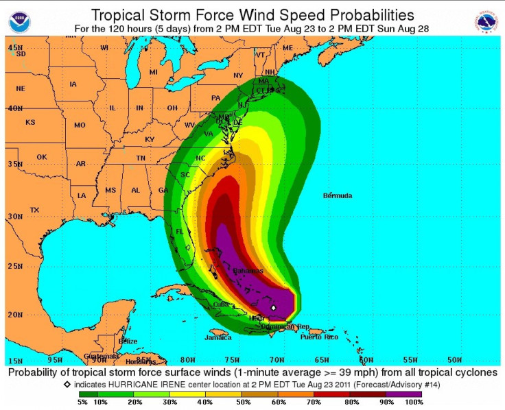
Five-day projections released by the U.S. National Hurricane Center show Irene heading for the continental United States, potentially making landfall in Florida, Georgia or the Carolinas.
This is a good time to get prepared again in your homes. There's items that you should stock up on, those that need to move or possibly be evacuated, perhaps seniors should think about having their medications refilled and having enough on hand, Nassau County, N.Y., Executive Ed Mangano told CBS New York.
Irene may intensify into a Category 3 hurricane by Thursday afternoon. At that juncture, Irene will be near Andros Island in the Bahamas and about 130 miles southeast of Miami and Fort Lauderdale, Fla., with a wind speed of 115 mph.
While South Florida remains a potential landfall spot, later computer models predicted an increasing threat level for the Carolinas.
Dennis Feltgen, a spokesman for the hurricane center, said Irene's projected path paralleling the Florida coast meant that a slight wobble or delay in an expected northward turn could push the powerful core from offshore onto a densely developed shoreline, the Miami Herald reported.
The stakes are high because it would take just a slight shift in the track to the left to make a dramatic change in the impact of the storm in a hugely populated area,'' he said.
A low pressure trough over the eastern U.S. will potentially shift Irene's track to the east, reducing the risk of a direct landfall in densely populated South Florida but raising the risk in the Carolinas, reports said.
The storm is tracking north of all the big islands in the Caribbean now, said meteorologist Brad Panovich of WCNC-TV in Raleigh, N.C. This is significant because now the storm will have little interference as it moves towards the U.S. This also means a shift in the track east squarely puts the Carolinas in the strike zone.
I would prepare now along the entire South and North Carolina coasts, he added. Preparing for the worst and hoping for the best is the goal here. Get your supplies and plan together today through Wednesday. Thursday we'll know who needs to activate that plan. If you wait you'll be fighting crowds for supplies late week.
Florida residents were asked to stay prepared and ensure essential supplies including batteries, drinking water and food.
South Carolina officials also warned residents to track the storm closely. It has been six years since a hurricane hit the South Carolina coast, Joe Farmer of the State Emergency Management Division told MSNBC.
© Copyright IBTimes 2025. All rights reserved.
- MOST POPULAR IN Science


